STUDENTS PROJECTS
PROJECTS 2011
Student: Stefanos Sampaziotis
Supervising professor: Aikaterini Liapi
Department of Architecture, University of Patras
Date: Thursday 30/06/2011
In this design thesis, a walking route with stops is designed in the settlement of the old town. Thus, the visitor is able to understand and deepen on a personal level the peculiarities of the landscape and the historic built environment.
THE TOWN
Kyparissia is located in the southwestern Peloponnese, Messinia, on the coast of the Ionian Sea. It is the capital of the Municipality of Trifylia and its population is estimated around 7000 inhabitants.
The story begins from the Mycenaean era, when the area was very crowded.
Soil morphology.
Over the centuries, the prosperity of this town was determined by the political management of its geographical position, at the unique landscape of mountain edges overlooking the sea and across the plains of western Peloponnese. Thus, its identity was always associated with the soil morphology.
Urban development.
A second factor shaping the identity of the town is the castle. The first signs of habitation in the area are related to residential development around it, as it was the citadel. Throughout most of history, Kyparissia developed exclusively in the area under and around the foot of Mount Egaleo and only in the late 19th century began gradually to expand the inhabited part to the plain, up to the coastline.

Zones.
Based on the urban development, we can identify three zones on the plan:
A) the old town zone at the foot of mountain Egaleo and around the castle,
B) a middle zone, where the old town meets the newer and the urban plan takes a more regular form,
C) the newer zone with the Hippodameian city plan.
Land uses.
The separation of the city into zones is not determined only by the difference in the urban morphology, but also by the density of different land uses for the area in which we focus. Trade, public and other services take place mostly at the current center, whereas land uses related to entertainment are mainly located on the blocks near the beach.
CHOOSING THE THEME OF PROJECT
Walking across the old city and documenting places, it was concluded that is very important the way in which any street "crowns" the flat landscape and leads the view from all points to the sea. As someone walks among narrow streets, the sea acts as a "common denominator of optical perception" with intermediate interruptions of old stone buildings, ruins and abandoned places with random vegetation. This conclusion was the key in choosing the theme of this work.
THE OLD TOWN OF KYPARISSIA
Access.
To reach the old town, we can follow either a primary uphill road, or a secondary zig zag road. These two roads join together in one that runs through the center of Old Town Square (Square Arcadia) and ends in a small square in front of the castle.
This point, which today is probably the end of our route from the lower to the upper town, was the entrance of the city, a few decades ago, in contrast to the current one at the newer highway. Within the intervention that follows, we propose to reuse the old entry with a new road-making shortcut north of the castle.
Landmarksa.
Until the early postwar years, the core of life in Kyparissia was located in the triangle formed by the castle, the square (Arcadia square) and the church of Agia Triada. During the second half of the 20th century, the center of life had been transferred permanently to the lower part of town, but the points mentioned above, still represent landmarks in the old town.
Today, we can add to them the building intended to accommodate the folklore museum, where until now occur several cultural events.

Zones.
The road that runs through Arcadia square and ends at the castle, essentially splits the settlement into two smaller areas. Thus, we can detect two areas-zones in the upper town.
Site selection.
In summary, we observe that the landmark triangle mentioned above, is part of the zone above the split line (road). Inside this area, there are certain points with ruins and wild vegetation, because of their abandonment for decades. They are "dead parts" of the settlement. However, it was discovered their option to become "promotion factors of the landscape", as they develop in space, ascending in steps and offer a diversity in views.
AIM
The aim is the revival of life in the area by designing spaces of cultural interest, and to offer opportunities for visitors to discover at a personal level, the landscape of the settlement. The lived reality that characterizes the area may be amplified by the visitor through a relevant, experiential approach to architecture. The effort is not aimed at adopting sterile modernity, or in imitation of the past. The timelessness of architectural intervention is received by proposing non-temporality constructions.
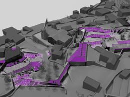
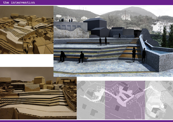
THE INTERVENTION
Basic principles.
Basic tools for intervention is firstly, the particular land morphology in section from the mountains to the sea, and parallel to the coastline and secondly, the elements of micro-scale within the area, such as the network of fences that divide the space. The sea view from any point is the common denominator throughout the process of intervention.

In addition, we cannot face the aspects of area holistically with fixed criteria in all subdivisions. The walkthrough, as a way of approaching a landscape is chosen to be the main feature of the intervention. The design must follow the specific nature of progressive revelation of passes, images and spatial concepts that only by walking with stops can be achieved.
The proposal.
It is proposed to develop an ambulatory path which will unify the landmarks, meeting the objectives outlined. Through the different circumstances of each sub-region, along the path, arise different design options and finally lead to two basic premises: first a square-balcony overlooking the sea, with tiered levels and then, an amphitheater area. In both cases, the existing topography dictated the functions. These two areas are perceived as "centers" the supplement or support of which is proposed through the reuse of existing buildings (ruined until recently) along the route.


However, the focus can only be given to the route itself. The buildings included in this are proposed simply as places to accommodate the necessary functions for intervention. Their full study as separate architectural elements could be subject for another design thesis.


Epilogue.
The visitor will go up to the old town, searching for the sights that it offers, and to have the experience of walking into a settlement with strong relief. Having climbed to the castle, he can detect the path and continue the tour. The experience is enriched by collecting information from the resource center (library), organizing meetings in the tiered square and participating in cultural events that take place in the amphitheater. The end comes in Arcadia square, leaving the path behind.