COLUMNS
ARTI-PHYSIS
5 November, 2008
FRAGMENTARY IMPUNITIES > VALLADOLID TRAJECTORIES (PART B')
At first view, the Las Raposas site appears as a non-urban underdeveloped zone with poor influences from the surrounding environment.
Not an agricultural plot, not natural either, partially neglected and occasionally used as a landfill, this blank slate appears as an ideal tabula rasa terrain. Still, in a more detailed examination of the urban and infrastructural information, the context of this locale re-merges as an exuberant sampling, an amazing manifestation of intricate and uncanny species of massive urbanization.
EUROPAN 8 ARCHITECTURAL COMPETITION ENTRY, FALL 2005
PART B' (<< PART A')
SUBVERSIVE CONTRASTS: At first view, the Las Raposas site appears as a non-urban underdeveloped zone with poor influences from the surrounding environment. Not an agricultural plot, not natural either, partially neglected and occasionally used as a landfill, this blank slate appears as an ideal tabula rasa terrain. Still, in a more detailed examination of the urban and infrastructural information, the context of this locale re-merges as an exuberant sampling, an amazing manifestation of intricate and uncanny species of massive urbanization.
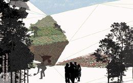
PRIMITIVISM: the Notion of the Cave. The prehistoric precedents in the region of Valladolid introduce the directive of underground enclosure and shelter, prioritizing a notion of visceral reconnection to the earth, the landscape, and the self. The name of the site “Las Raposas” [=the foxes] brought into attention the foxhole as a possible reference. The concept of the cave as a habitable enclosure strengthens the connection with an environmentally conscious approach as a constant engagement and response to nature.
EMBEDDED ACT: This directive addresses issues of land preservation and sustainable habitation with minimal visual disruption, while taking advantage of the natural topography. Addressing the greater urban issues of the site was not possible within the scope and scale of the project. Also, a simple visual formation set on-top of the ground and disturbing the topography was simply not tackling the problematic of addressing a rural tabula rasa in a grounded fashion.
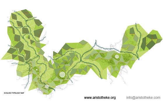
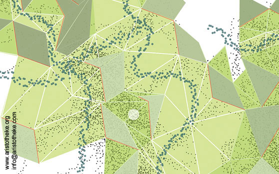
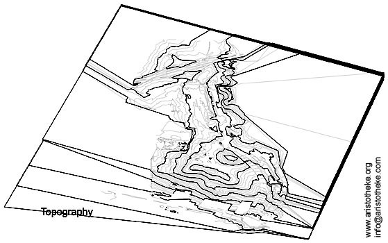
CARVING: The final concept acts through gentle ground manipulation, removal and re-use of soil within a pre-defined perimeter. The naturally sloping topography is geometrically translated as a triangulated surface sheltering submerged modular housing, a man-made, constructed hillside that minimizes impervious surfaces. The “quarry” concept focuses initially on the development of an underground inter-connected cave network, establishing a mystical prototype for submerged living on a natural slope. The motif of the natural contours in conjunction with the below-grade network establishes an infrastructural tectonic drainage system. The geometric pattern of seemingly Fuller-ian triangulation will in reality show solely as a smooth and boundless undulation of the land, with
zones of varying inclination and use. The sharp edges are only the geometric outlines of the programmatic subdivision and above all, of the geometric distribution of variable ground-scapes. The natural soil, as the basic visual element of the landscape will smooth out all edges therefore the triangulation will not
be experienced harshly.
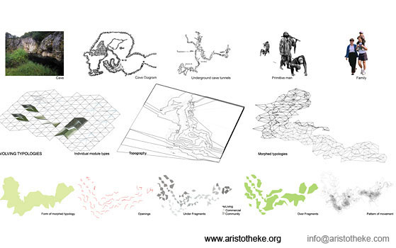
GEO-METRICS: All topographic manipulation is the effect of stretching points on the ground surface, restricting any additive operations that would separate the building envelope from the underlying supportive surface, reducing the proposal to an object-on-a-base archetype. Using a concept of planar surfaces, fragments from the city grid were proportioned three dimensionally, and then further sliced and used as carving motifs to form cave units. In a truly sustainable way of living, the user is then completely enfolded within the land. In return, the ground is pulled and dissected into underground spaces that equally accommodate habitation patterns. The geometric operations are very simple: the final topography is the outcome of striating, shearing, folding and stretching of a singular surface; of the simplified abstract shell of the natural topography. For each triangle, the ground at the front end is pulled up, while the back is pushed down generating a pattern of earth pockets that become the habitable portions of the parti. A number of versions of varied complexity were tested for the ground formation.
INSERTED POUCHES: The cave-like below-grade spaces are conceived and formed as de-rocking sculptural attempts, where mass is carved out of a solid generating sectional properties fit for habitation. A number of versions of varied complexity were tested for the unit formation.
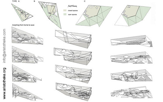
HOUSING TYPOLOGIES: Housing typologies present in the neighboring areas were investigated and morphed into nontraditional typologies. The site targets not only families of varying size, but individual students and workers present in the surrounding areas. Specifically, the units target an urban audience interested in
dynamic, innovative forms and non-traditional, environmental living conditions. Each unit contains not only personal space for living, but further outdoor space for leisure, gardening, and recreation.
LIVING PARAMETERS: The housing units follow the natural topography geometrically translated into triangulated modules. These south/southwest facing housing units are oriented to optimize a primary sun exposure, carving back into the hillside in a contemporary translation of 'cave'-type dwelling with light and air wells for cross-ventilation, mechanical vents and chimneys integrated into the insulated 'poche' side of each unit or in vertically stacked party walls. Clerestories were also examined as opportunities for localized deviation from the normative pattern, also as solutions for deeper illumination into the sub-terrain spaces.
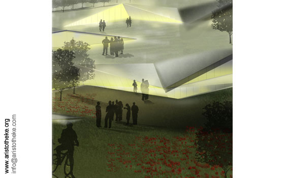
PROGRAMMATIC DISTRIBUTION: this geometric subdivision becomes readily the infrastructural substratum: courts, roads, parking areas, communal zones, public areas are identified in a cause-and-effect manner of simple logical and inter-changeable allotment. Regardless of the location of the housing units, all ground surfaces [including the roofs of the units] are utilized for common urban functions. Fronting the open side of the earth-pocket dwellings is always a private court.
Edging the house-and-court entities and operating diagonally are public routes, sloping downwards, accommodating “green” vehicles and other means of transportation.
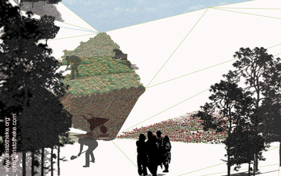
ECO-SURFACING: This contructed hillside mitigates the urban heat island effect of surrounding development by maximizing pervious surfaces and minimizing impervious or paved surfaces. Site erosion and rainwater run-off are reduced by vegetative zones. The drainage paths are designed to follow circulation paths finally collecting into filtration ponds that double as water features in buffer zones. The site circulation incorporates a network of 'grasscrete' or semi-pervious paths for vehicles belonging to residents and public transit.
TRANSIT INTRICACIES: Energy, water and other conservation strategies, as well as proactive environmental mitigation, waste management and energy production initiatives are incorporated into individual housing, common areas, commercial uses and site development. Strategies for site circulation and regional interconnectivity are designed for car travel demand reduction, and for maximum walkability. Cycling paths and small alternative powered carts enable circulation options for all ages, physical capabilities, and weather conditions. Transit connectivity is planned with site locations for trams, or light rail stops.
ANTI-PETROLEIC: Vehicles are alternatively fueled with bio-fuel and other alternative energy sources. Re-fueling stations as well as production of bio-fuels and other alternative fuels are represented on site in demontration semi-industrial/agricultural zones. On-site crops may support the partial independence of the community from external resources and suppliers, generating a largely self-sustainable enclave. The site integrates alternative energy semi-
industrial/agricultural zones, including 'solar farms' which are 'fields' of photo-voltaic panels, collecting and generating energy for site uses and [commercially] for supplemental energy to regional utilities.
RESPONSIVENESS: This concept development incorporates environmental design strategies that are both passive and pro-active for earth, air and water resources; for heat island mitigation; energy conservation via site circulation; building materials and systems design, as well as strategies for green spaces and public gathering spaces. Energy conservative features include overhangs and windows positioning for summer sun shade and winter sun exposure; indoor air-quality criteria to eliminate emissions, mold and mildew; solar powered energy systems for residential heating, cooling and lighting; building materials selection parameters for environmentally conservative attributes, such as recycled material, aluminum and terrazzo, fast growing woods, and low-energy production
materials; waste management via allocated areas for constructed wetlands (per Rocky Mountain Institute guidelines); water management with rain water collection and engineered drainage systems; water collection and re-use for landscaping; cleaning site water before returning to river.
QUANTITATIVE: The finite density accommodates approximately 300 units of varying size and program, resolving all formal questions through the incorporation of the habitable volumes into the ground mass. The development, as suggested by the competition brief, is concentrated in the pre-assigned intervention area. It is not a universal concept to be repeated endlessly. The site encourages residential and industrial growth by targeting an economically and environmentally
conscious user.
Aristotelis Dimitrakopoulos.
Related articles:
- HORROR VACUI: JOSTLE, HUDDLE AND HELLENIC MODERNITY ( 21 June, 2005 )
- ATTIC ECTOPIA ( 16 November, 2012 )
- FRONTAGE SHOWCASES AND THE POST-URBAN UNCANNY-A RECTROACTIVE MANIFESTO FOR HELLENIC PROFESSIONAL SPACES ( 01 January, 2010 )
- VI: Unrecycling Cyclades. Part 1 ( 04 October, 2010 )
- Gwangju Asian Cultural Center, Korea – International Competition Entry, October ( 7 December, 2007 )
- De-institutionalizing Education: Notes on Academic Initiatives(i) ( 7 July, 2007 )
- HARBORING CAR-BAN-ITIES [Port Nord Organizational Protocols] ( 8 October, 2007 )
- Stratifying Axialities> Celadina ReCelled (PART A) ( 14 March, 2008 )
- Stratifying Axialities> Celadina ReCelled (PART B) ( 11 April, 2008 )
- FRAGMENTARY IMPUNITIES > VALLADOLID TRAJECTORIES (PART A') ( 5 September, 2008 )
- SUBTERRA * SUPRATERRA ( 22 May, 2009 )
- VI: Unrecycling Cyclades. Part 2 ( 14 October, 2010 )
- Translocality as a Post-Native Narrative ( 16 February, 2011 )
- Metaxekisis : Re-Thinking the Athenian Court ( 08 December, 2010 )
- L-I*-THEKE ( 02 April, 2013 )
- House - glyptotheque - gallery - workshop ( 19 July, 2013 )
- Piloting Pilotis ( 31 December, 2013 )
- Escalteca of the Choetheque Series ( 01 April, 2014 )
- Schottheke of the Choetheque Series ( 01 June, 2014 )
- Floatheca Rh of the Choetheque Series ( 01 August, 2014 )
- Floatheca Sp of the Choetheque Series ( 26 September, 2014 )
- O-theke of the Choetheque Series ( 11 March, 2015 )
- Floatheca Cy of the Choetheque Series ( 03 January, 2015 )
- Ophthalteca ( 24 June, 2015 )
- Y-theca of the Choetheque Series ( 08 October, 2015 )