COLUMNS
ARTI-PHYSIS
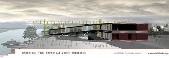
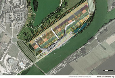
![HARBORING CAR-BAN-ITIES [Port Nord Organizational Protocols]](https://www.greekarchitects.gr/images/news/Aristotheke-Euro8-Frtramp_389095951.jpg)
8 October, 2007
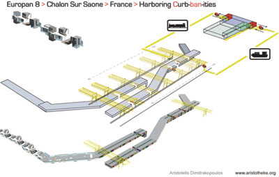
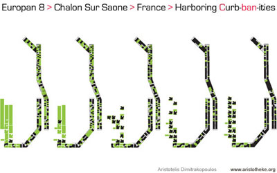
HARBORING CAR-BAN-ITIES [Port Nord Organizational Protocols]
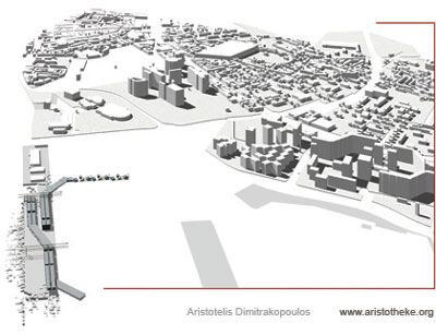
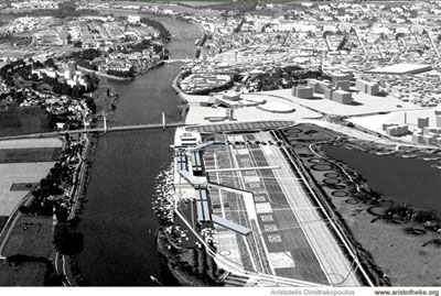
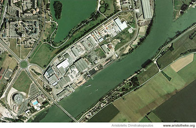
The Port Nord site is located in central France, at the outskirts of the city of Chalon sur Saone. The intervention area is a typical central-European waterfront no-man's-land, a derelict logistics sector appropriated by industrial activities and transportation circuits; currently largely obsolete, a territory hostile to human habitation amidst a surrounding context of physical beauty...
DATA: This europan 8 competition entry is the product of a 14-day charrette in the fall of 2005. Team leader was Aristotelis Dimitrakopoulos [Architect, Dipl. Eng NTUA, M.Arch. Yale]. Collaborators were the architecture students Lucas Correa and Peter Glasson.
PLACEMENT: The europan site was in central France, at the outskirts of the city of Chalon sur Saone. The intervention area, Port Nord, is a typical central-European waterfront no-man’s-land, a derelict logistics sector appropriated by industrial activities and transportation circuits; a territory hostile to human habitation amidst a surrounding context of physical beauty.
INHABITING A PORT: the experiential objective of domesticating the industrial port and regaining the riverside environment is achieved through multiple layers of intervention [as outlined in this paragraph and analyzed minutely in individual paragraphs].
TECTONICS: the main tectonic approach establishes clear associations and visual references to harbor life. The operating and the re-used [abandoned currently] gantries and cranes, the industrial warehouses and silos [preserved and renovated to work as large-span enclosed venues] keep a visual continuity with the previous state of existence on-site.
ORGANIZATIONAL PROTOCOLS: most importantly, the main attribute is the incorporation and re-evaluation of organizational patterns originating from cargo handling processes. These organizational patterns are transposed as a re-elaborated stratum of intellectual potential. The proposed residential scheme, the elevated re-configurable and highly mobile cargo-housing/shelving system is the most representative feature addressing this directive.
CONCRETE BLOCKS: these primary landscape elements allow for a range of experiential feats: the combination of the hard-paved river edge with the elevated metallic tectonic forms generates a context for the “harboring flaneur”. Through the seemingly randomized concrete-block-scape, the generated broken [defragmented] river edge becomes user-friendly for the new non-cargo activities, offering a mutable environment for direct individual interaction with the waterfront taking into account the practical issue of the extreme fluctuations of the water level. This man-made water edge is reborn on a daily basis, in response to the volume of high-current water covering the concrete blocks and allowing variable projections of the blocks over the water surface. The long-term sculpturing of the blocks by the fast moving waters of Saone ensures additional experiential effects: varying water sounds, waves crushing onto the blocks, small boats discovering quasi-naturalistic havens safe from the current and accessible by the more adventurous pedestrians. The artificiality of this hardscape keeps clear connotations of a harbor edge.
NAVIGATIONAL PATTERNS: Mobilization patterns and cross-connectivity between the lake edge and the river bank becomes a primary element of visual directionality. “Randomly” positioned cross-routes, thinned strips of landscape along straight lines connect the river to the lake, providing a sense of visual clarity and control for the newcomer [user, dweller or tourist]. Even from the ground level and at any time, and any point, there is a sense of total overview of the circulation options, the potential destination points, and the intriguing urban moments.
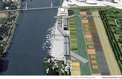
RE-USED BUILDINGS: The series of warehouses and silos at the edge of the site towards the bridge will be preserved as to accommodate cultural events and community needs at large; such as the boat transportation node, a low-profile ferry terminal, an info center, along with a plain foyer-type space, or communal gathering spaces for athletic groups [cyclists, runners, water sports addicts, etc.], and perhaps basic services [post, bank, etc.]. There was a clear intention to avoid the implementation of “design object” buildings along the harbor lines. Such a particular design approach was judged as outdated and banal [a designer trying to design disparate building forms]. The choice for the re-use of the existing buildings reinforces the inhabited port effect, saving resources [financial and material] while allowing the overall urban scale proposal to read as a strategic plan rather than as a fragmentary design exercise in formal hedonism.
LANDSCAPE INTENTION + OUTSET: The notions of mobilization, of impermanence and the secret promise of recovering the site to a previous stage of natural existence, form the dynamics of the project. On one hand the attempt for an exhilarating visual imagery is obvious, on the other hand the site is treated with great sensitivity at an environmental level, dealing with aspects of sustainability and recovery that have been of great importance in the development agendas of local authorities. Chalon sur Saone has demonstrated a significant record of attention to environmental issues, and the Port Nord site becomes the ultimate epicenter sampling the future of the city.
LANDSCAPE CONCEPT – ENVIRONMENTAL SAMPLING: clarity of organization was the central goal for the site planning phase. The horizontality of the landscape is accentuated with the straightforward placement, parallel to the river banks, of strips of landscape elements. From the lake towards the river, the natural [in recovery] landscape, is progressively transformed to man-made green patterns, and then becomes a tectonic, solid, hard-scaped zone by the riverfront. The visually fascinating spectrum of landscaping types combines what one would call odd juxtapositions: corn crops, biological agriculture, communal gardens, forest strips, hedge/park zone. The uncanny coexistence of the above entities is conceptually interwoven through the soil sustainability goals. The primary landscape pattern of the parallel strips of diversified vegetation densities acts as a tight environmental infrastructure, a steady and strong condition of reference, a striated plateau upon which the more point-like or line-like urban relations occur.
WHARVES – SECTIONAL FLUX: the current height of the concrete wharves forbids any interaction with the river water at a pedestrian level, and forbids the accommodation of small boats used for transit to downtown, for small cruise-ships, or medium-size private vessels. Reflecting the concept of defragmentation / decompression, the uniform artificial plinth of the wharves is broken down into individual rectangular solid blocks organized in an orthogonal system for placement [in plan] and varying in height in section. A gradual randomized stepping configuration emerges, as a challenging landscape feature, inviting the pedestrian urbanites to walk from one block to the next, allowing contact with water in a variety of ways: feet splashing in the water, to diving, fishing, swimming etc.
WHARVES – PEDESTRIAN CONTACT WITH WATER: the relation of these individual platforms to the water is in a state of constant flux, depending on the water level and the season. In this way, the issue of the fluctuating water level is no more an inconvenient factor of unpredictability, but transforms into a parameter of mobilization, of constant reconfiguration of the waterfront, with some blocks being for periods of time underwater and during other seasons above water.
A sense of personalization immediately emerges, as dwellers, visitors or urbanites are potentially expected to develop emotional preferences with individual segments/concrete blocks, reinforcing a sense of personal identification with the waterfront.
WHARVES – SMALL AND MEDIUM-SIZE VESSEL ACCOMMODATION: the concept of braking down the wharves into segments with randomized sectional configuration relates further with the accommodation of smaller boats. By eroding the current, highly linear and austere artificial edge, individual smaller canals emerge, controlling the issue of high current of the water, and allowing smaller boats to tie up to the shore, and engage visually into the energized waterfront environment.
The multiplicity of interaction levels with the water relates to the common French strategy of having two riverfront conditions: a lower bank for strolling, allowing direct contact with the water, and a second upper edge, at the city level, dealing with extreme flooding scenarios. The condition is common in Paris, with a more serene and pedestrian-oriented river bank and an upper bank, responding to the urban energies of the city.
WHARVES – MARITIME HYDRO-SCAPE: the high current of the water becomes a fascinating feature, promising on one hand a constantly active water edge, with waves eating up the solid blocks, generating an environment that addresses all senses: sound [water hitting the concrete blocks], smell [moisture and evaporating water], vision [a lively artificial beach condition]. Because of the high current, water can circulate and renew within deeper canals/patches/recesses that eat up into the land generating more isolated water hubs.
HYDRA-CITY: the new urban amalgam is generated by merging the concept of the paved urban plaza with the condition of the waterfront. This landscape is expected to act as a very desirable destination allowing a number of sports activities to find there a departure/arrival hub. From water ski, rowing, or even surfing to swimming, fishing, diving, the urban zone is expected to trigger the interests of everyone by focusing on physical activity beyond age barriers. Diverse zones for everyone are included: bathing/swimming for the elderly, extreme sports for the youngsters and for the family-oriented a water educational locus allowing the kids to familiarize themselves with the experience of the water.
WHARVES – HYDRO-POWER: the potential incorporation of hydraulic energy-producing devices becomes a more practical way of utilizing the high current. This strategy responds to the high-levels of environmental consciousness of the city, and belongs to the sampling of environmental strategies that animates the site, promoting an educational agenda that focuses on urban ecology. [Introducing more energy production strategies on-site].
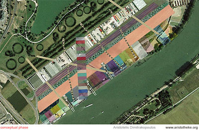
PHASING: It is expected that the proposal will operate well even with the lowest of building density. In effect, the landscape and site concepts could work even with no new buildings. Beyond this assumption, a number of density patterns have been considered through a timeline.
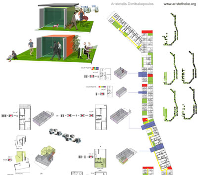
PHASE 1: The existing gantry is used as a suspension device for an ultra-long housing strip, elevated from the ground, and supported on pilotis in one end, while turning vertically to merge into the ground at the other end. Beyond the pilotis the strip extends across the site, reaching the flood-plane, where it turns again parallel to the riverbanks, defining a dispersed development. The housing strip structure, typologies and attributes are defined separately in individual paragraphs.
PHASE 2: A new gantry is installed on-site, regaining the status of an operating cargo port. The primary function of the gantry is to move, relocate and position housing units along linear elevated strips that develop along the river frontage. A C-shaped waterfront development defines the site, expecting further infill growth.
PHASE 3: More perpendicular strips of housing develop, not associated with gantries at this stage. The typology of the habitable elevated strip becomes a primary tectonic feature of the site. These are potentially overlapping with the earlier strips, and merge with the ground. The trusses turn vertically to stop on the ground in many cases. In parallel to the continuous strengthening and growth of the streets, it is expected that a second urban zone will grow in parallel to the river, focusing on services, always associated with the immediately adjacent landscaped strips, and conforming to the transverse connectors. The potential of the urban boulevard gains strength at this third stage where businesses and professional space starts to be at higher demand.
AIRBORNE HOUSING STRIPS: the existing gantry is utilized as a bridging structural device that supports single-storied strips of housing through suspension. The existing gantry is expected to stay out of its original use, and will be permanently attached to the ground. Through simple structural reconfigurations, the gantry will serve as main structural member of the underlying housing strips. This incorporation of the harbor infrastructure into the housing scheme accentuates the attention and the overall focus on maritime identity, on post-industrial housing prototypes concepts.
Through the utilization of the existing gantry we were able to implement an abstract concept that would otherwise seem unrealizable: a hovering, elongated, segmented strip with slight kinks along its length in section and in plan, finds now an ideal support element: the gantry, re-emerging as an external structural skeleton is clearly of different [utilitarian] nature than the slick housing strip, therefore does not impose the problem of spoiling the linearity of the airborne housing bar.
GANTRY – A HOUSING STRUCTURE: simply put, the same exact infrastructure that was fully dedicated to logistics in a non-habitational enclave, the industrial port, reflecting insofar notions of blunt utilization of environmental resources, can now fully service the direct needs of human habitation in a highly vibrant environment. The container port infrastructure offers this way a lot more than a simply symbolic presence connoting the past. It embodies a sense of energetic continuity with the history of Port Nord even if there is a clear transformation of the organizational basis and of the functions incorporated.
VIERENDEEL HOUSING STRIPS: the structural system that is accommodating the housing strip is absolutely straightforward. A common vierendeel [cage] truss of rectangular cross-section [approximately 4meters tall] allows [in cross-section] its horizontal members to extend on either side, cantilevering outwards. The truss spans from the gantry to support points connected to the ground on either end. The linear members composing the vierendeel truss are welded rectangular-section steel tubes. The horizontal surfaces of the truss are clad in steel plate, similarly to the decking concept of a boat. It is expected that the truss will be constructed in nearby shipyards and will be moved and finally welded on-site.
MARITIME STRUCTURAL PROTOTYPE: the final cross-section is a hybrid prototype utilizing the strengths of a vierendeel truss and the lateral rigidity of a sandwich structure. The symmetrical cantilever on either side of the cross-section allows three zones to occur: thinner linear bands on either end of the structure can be utilized as circulation corridors or as private semi-outdoor shaded zone on the opposite side, the equivalent of balconies or verandas. The central zone is wider and acts as the main spatial entity that accommodates the housing units. In effect, there is a constant flux in the configuration of these spaces, and not an imposed linear holistic order. In that sense, any kind of mixture of public-use and private spaces, pulled and pushed asymmetrically in cross-section, are welcome in this configuration. It is expected that this integral organization will be in a state of constant flux responding to probabilities and statistics of real estate dynamics.
VIERENDEEL SUPPORT POINTS: the most accentuated [visually] structural node for the elongated strips is clearly the gantry juncture; however, the other support points are equally intriguing and responsive at an urban scale. On its end, the steel-plated strip folds vertically and merges with the ground, providing a vertical circulation node. This is a major access point and simultaneously a pin-point for development and visual reference on the ground level. Towards the other side, the steel-plated strip turns in section and in plan, becoming a ramping feature, accommodating a stepping housing configuration [refer to housing analysis]. At the end of the ramp, the strip becomes again parallel to the ground [horizontal in section] and is supported by a forest of randomized columns, forming a linearly developing piloti. The pilotis become major landscape features, as the strongest shaded surfaces, accommodating functions that range from parking to ephemeral markets, to pick-nick spots etc.
FIRE EGRESS: sets of outdoor stairs are embedded within the section of the gantry vertical lattice frame supports. Occupants can be moved onto the roof of the housing strip, outdoors, and may use the ramping surfaces to evacuate the structure. The cross-sectional exposure on both sides and the linearity of the strips helps to identify and resolve fire emergencies before a larger portion of the structure gets affected.
The greater component of the fire egress system is that the moving [new] gantry is by default the most powerful component for the resolution of fire emergency cases. The gantry serves as a giant fire extinguisher moving along the frontage of the strip and operating in all [x,y,z] axes, exactly in the same way it circulates housing units or products. Through catwalk corridors embedded within the horizontal portion of the filigree frame, and stairs within the vertical sides of the steel portal, people can be moved from any portion of the housing strips to the ground.
ACCESSIBILITY: the ramping portions of the housing strips have a very gentle slope of 2.5% allowing convenient cargo, elderly and disabled circulation. All ages and health groups have equal rights of access and above all, equal experiential patterns of mobility. The full length of all housing strips is fully accessible by people on wheelchairs. Elevators are offered at the ends of the strips for circulation at a faster pace.
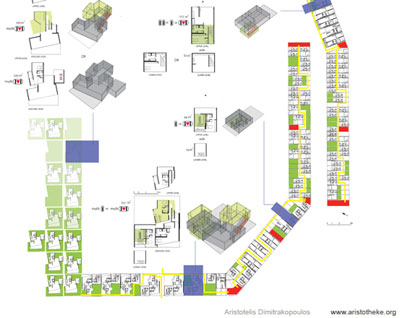
HOUSING TYPES: the housing strips mutate progressively covering a full spectrum of housing typologies: prefabricated removable units fit for social housing allocated to persons or families of lower income for limited periods of time -therefore reconfigurable; permanently embedded units along the second segment of the strips [the ramping portion]; a rowhouse sector that stands on pilotis -establishing a first contact with the ground; a progressively semi-detached system that brakes perpendicularly the continuity of the long strip introducing voids; a detached housing zone responding to the boundaries of the original strip; then finally a morphed, complex series of buildings celebrating formalism; arriving progressively through height increase to a potentially commercial entity -of detached taller buildings.
GANTRY – HOUSING MOBILIZATION + APART-MENTALITY: if the first reference to the industrial container port [the previous function] is evidenced through the incorporation of the existing crane to the structural concept then the second reference goes full speed: a new, fully operable crane is actually introduced, receiving prefabricated units by boat or railway [fully customizable during production] similar to shipping containers. The units are inserted by the gantry onto the elevated housing strips [the shelving system]. The units enjoy a very privileged elevated overview of the river and a variety of public use spaces on the strip. The concept is one of a linear arrangement that almost randomly fluctuates in section and varies in occupant density for different periods. This arrangement, detached from the ground, enjoys the advantages of an apartment tower configuration becoming an organizational device for a number of typologically differentiated housing entities.
RENTER VS. BUYER: the clear distinction between the two groups and their relation to the site is articulated through the arrangement of highly mobile housing units away from the natural ground, and in distance from the detached housing. The nature of this forefront housing arrangement and the mobilized container strips allow for short-term occupancy by tourists and other non-permanent groups. The distinction between social housing and hotel-style accommodation merges here into one entity, allowing for intricate dynamics between members of radically differentiated social and economic standing. The wealthier leisure visitors, tourists and jet-set nomads mingle with the socially assisted locals, re-negotiating social barriers.
SHIPPING LANDSCAPE: the shipping container form appears as a series of types and becomes the prototype for enclosed spaces developed on-site. A system of distributed semi-mobile vendors [refreshments, light food and café bars] is accommodated in reformed containers servicing visitors, athletes, dwellers, tourists, right in the outdoors. There is a level of elitism that characterizes a great number of shipping container projects in the recent age, however our project is differentiated in a straightforward way: the notion of the industrial port is not simply a past memory, but is at the same time the presence. The industrial port is still fully operable, regardless if the river frontage has been overtaken by housing: containers can still be unloaded from the ships and delivered to trucks, even if the stockyards have transformed from hard-paved expansions to a green landscape.
STRIP GRADATION – SLOPING CONDOS: knowing that there would be high demand for the high-view apartments, a second, less frontal section of the strips is occupied by structures of a beach-house feel. The housing structures are permanently embedded into the mega structure characterized by the hybrid vierendeel system and feature more luxurious interiors. Combining aspects of outdoor and leisurely living, the tilted rowhouses feature private patios and open atria-courts. The composite welded steel roof plate is punctured to allow for sunlight to enter through. The puncturing occurs between the main structural ribs, not affecting the structural coherence of the cyclopean girder.
Similarly, the puncturing occurs on the floor plate, with small rooms occurring on a lower level, hanging below the main structure. Such bays of upward and downward protrusion are set side by side, reforming the rigid archetypal form of the container parallelepiped and exploring the sectional properties of the slope. The sectional complexity becomes a celebrated feature, suggesting the consequent further dissolution of the solid linear forms.
PILOTIS SECTOR – ROWHOUSES: beyond the ferrous gantries, the metal mega-strips find their second structural support zone on pilotis that keep the vierendeel truss approximately 4 meters above ground for a linear segment. The loads are transferred to the ground through a randomized forest of columns. This means that the upper plate of the structure becomes redundant. Progressively the roof plate is punctured away and the new structural system is “a plate on stilts”, holding a more diverse series of housing units on top. The continuity starts to erode in a sectional manner too, therefore gaps can be seen in the rowhouses series [because of the missing roof slab].
ON-GROUND SECTOR: at the end of the pilotis, the rowhouse system brakes further and finally the detached housing takes over as a deposited series of fragments, remnants of the deteriorating steel strips. This becomes the normative pattern that allows more solid relations to occur with the adjacent spaces, enabling the development of urbanized streets and normative urbanism. The car streets front these housing and mixed use sectors. This is “the-city-as-we-know-it” sector that can allow for significant growth during consecutive development phases. The on-ground building lines mutate from the more conventional single family maisonettes to more challenging building shapes that defy the already dissolved steel strip layout. As the building density and proximity lessens, a progressive change of function is anticipated, with the building typologies morphing progressively into gradually taller, volumetrically simplified structures for commercial use, offices, stores.
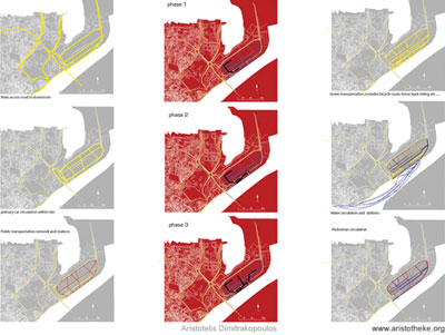
URBAN BOULEVARD: two parallel roads [for private vehicle use] are introduced along the site, merging only at the two ends of the Port Nord study site, generating a clear axis of street-side urban growth. This growth is anticipated in consecutive development phases. The traffic flow smoothly merges with the newly-introduced North-South axis road that connects to the north end beyond the lake. The width of the road and the conditions established at the Port Nord site formulate possibilities for intense street-side activity, fostering the evolution of an urban boulevard rather than a mere connection road or a motorway.
The main accomplishment of the urban plan is the definition of an exciting destination zone triggering movement along the north-south axis, generating a flow of people coming from the north towards the site and an uninhibited, flawless connection to the city center through multiple means of transportation: from the ferry transit, to private car routes, to cycling and pedestrian or horse-riding networks, buses, or small train [tram or trains on wheels] networks. In this sense, ensuring that the two ends of the north-south axis are strongly defined, residential in the north and leisure, landscape/mixed-use in the south [our site], the potential of progressive densification of the in-between strip can be strong, particularly because the landscape characteristics of the north-south strip of land between Saone and the lake reservoir will appear equally strong.
CITY CENTER CONNECTIVITY: as demonstrated in the city-scale diagrams and partially in the site plan, a network of roads is reinforced to support mobility patterns towards the Port Nord site. Ranging from car traffic to public transit systems, boat transportation and linear sports networks, the connection promise between our site and the city is strengthened. Of particular interest is the proposal to continue the waterfront roads from the Chalon City Center under the motorway bridge, and into our site, creating a reformed roundabout that closes the loop of primary circulation from the city.
HARBORING CAR-BAN-ITIES: this title is a lectic play between Ban-ning the Car [Car-Ban-ity] and the word Urbanity. The competition brief states strongly the intention to reduce the use of the car and promote alternative networks and patterns of mobility. The proposal clearly gives attention to the moderated inclusion of automotive circulation, avoiding utopian chimeras and ensuring a coherently and densely organized network of alternative urban or landscape elements to organize the living experience. The common cliché of setting street pattern design as the foremost regulatory tool for urban planning is here rejected. Urban design is not traffic engineering, and the experiential qualities focus instead on uncommon sets of relations between the natural and the man-made landscape.
A stretched round-about configuration would hug the site of the soon-to-be-built bowling center. This in-between zone screens partially the rough automotive bridge, by extending the parking facilities of the bowling center, becoming the primary automotive drop-off area. This feature suggests the use of other means of transportation through a series of closely spaced individual destinations, and above all, reinforces walking along and across the riverside promenade.
CAR-PARK + GREEN TRANSPORTATION NODES: it is clear that large and singular car parking areas worsen the visual effect of countless automobiles dominating the landscape. We propose a main drop-off center close to the bowling center, however; there is provision for a tight network of smaller parking areas, or side-street parking, potentially to be implemented in following stages of urban growth. The creation of transportation interchange nodes, with bicycle parking, car parking, bus or tram stops, combining with small retail options and café or brasseries, ensures a network of lively point-like areas of relative concentricity. These nodes are located at the piloti areas supporting the large steel housing wings. For the first phase of the development, this intricate small retail network can be adequately compensated by a light and mutable network of vendors using container like units.
SOIL RECOVERY: the industrial use of the site almost confirms the existence of soil pollution at a certain degree and perhaps toxicity hotspots. This is only a speculation relating to the nature of the cargo circulated on-site in the past. The strategic brief of the proposal includes a certain number of strategies tackling such environmental issues.
SOIL DECOMPRESSION: the site has been heavily paved for extended periods of time, and this fact translates into poor soil quality after demolition. The process of recovering and decompressing the densely packed soil is gradual, if implemented through natural [slower] processes. The easy solution of bringing in new soil is regarded as essentially anti-sustainable, as this soil would need to be scraped from another natural site [disturbed at a great degree] and transferred egotistically into the Port Nord site. This was not a desirable option. Instead, the slow process of regaining the soil quality could include the cultivation of low vegetation that in progressive years would enrich the soil ingredients. A series of strategies is analyzed here.
CONSTRUCTED WETLANDS: the existence of water from the river and the lake and the great amounts of water run from the extended roof slopes offer the possibility to implement a zone for artificially developed wetlands, with the intention to develop eventually land that can be used for larger vegetation.
RETAINING PONDS + WATER CLEANSING: in relation to the potential creation of constructed wetlands and perhaps in a more simplistic and immediately effective vision for the site, the project suggests the creation of a demonstration site for water cleansing processes. Water can be progressively filtered and directed to the river through a series of retaining ponds. The visual effect of the process is embodied into the landscape concept.
BIOFUEL CROPS: the potential use of corn crops on-site as a demonstration feature for the production of biofuel, [ethanol as an alternative energy source allowing a certain off-grid energy capability] offers visually a desirable landscape effect. Rural life enters the urban environment in close proximity with high-density off-ground development.
NEW SOIL SECTOR: for immediate development, only a small portion of the site is planned to accept new and healthy soil so that faster-pace landscape effects start to emerge. For the greater portion of the site the strategy is to recover the existing soil, as a statement of true dedication to the locality and to non-commoditized understandings of quality of life.
BIOLOGICAL AGRICULTURE SITE: the promise of showcasing organic agriculture on-site, and the scenario of self-sustainable food resources becomes another striking landscape feature.
SOLID BLOCK MOUNDS – SOIL ENCAPSULATION: acknowledging the possibility of polluted or intoxicated soil on-site, we propose the enclosure of toxic hotspots in paved areas. This strategy prevents in a rough way the transmission of pollutants to neighboring soil and water. This is a short-term effect enabling the immediate use of the site. At a later stage the method can be re-examined to give way to more sustainable recovery strategies. These areas are paved and enclosed with concrete at a great depth vertically and also horizontally. For our landscape proposal, these are potential areas for the creation of small artificial mounds using the randomized stepping pattern of concrete blocks that is [as aforementioned] also implemented on the riverfront. These spots are expected to function as primary destination areas for a number of leisure activities, pick nicks, readings, sunbathing, etc. enjoying a more elevated view of adjacent natural features.
DEMOLITION WASTE: it is expected that demolition waste will be recycled, cleansed from pollutants, and potentially recovered for use on-site. The large surfaces of concrete paving, the existing buildings and structures, can be re-used for the development of the aforementioned artificial mounds.
HARDSCAPED RIVERFRONT PROMENADE: the constructed edge of the water remains largely tectonic with hardscapes allowing increased public pedestrian circulation. The zone close to the water remains largely open with no building footprints. A very thin circulation tower leads to the elevated housing enclave. This tower along with the pilotis of the steel airborne housing strips, are the primary visual elements. The colossal portals of the gantries and cranes define framed views. The river-side walk is at a great extend shaded by the large volume of housing hovering above.
URBAN FORUM: movement and place-making is defined through surfaces or lines: the horizontality of the ground and the elevated steel ribbons generate a certain sense of enclosure, while the cranes with the stepping, randomly placed blocks, generate a sense of stage-like theatricality generating high dynamism, an urban forum.
Aristotelis Dimitrakopoulos, 2006.
Related articles:
- HORROR VACUI: JOSTLE, HUDDLE AND HELLENIC MODERNITY ( 21 June, 2005 )
- ATTIC ECTOPIA ( 16 November, 2012 )
- FRONTAGE SHOWCASES AND THE POST-URBAN UNCANNY-A RECTROACTIVE MANIFESTO FOR HELLENIC PROFESSIONAL SPACES ( 01 January, 2010 )
- VI: Unrecycling Cyclades. Part 1 ( 04 October, 2010 )
- Gwangju Asian Cultural Center, Korea – International Competition Entry, October ( 7 December, 2007 )
- De-institutionalizing Education: Notes on Academic Initiatives(i) ( 7 July, 2007 )
- Stratifying Axialities> Celadina ReCelled (PART A) ( 14 March, 2008 )
- Stratifying Axialities> Celadina ReCelled (PART B) ( 11 April, 2008 )
- FRAGMENTARY IMPUNITIES > VALLADOLID TRAJECTORIES (PART A') ( 5 September, 2008 )
- FRAGMENTARY IMPUNITIES > VALLADOLID TRAJECTORIES (PART B') ( 5 November, 2008 )
- SUBTERRA * SUPRATERRA ( 22 May, 2009 )
- VI: Unrecycling Cyclades. Part 2 ( 14 October, 2010 )
- Translocality as a Post-Native Narrative ( 16 February, 2011 )
- Metaxekisis : Re-Thinking the Athenian Court ( 08 December, 2010 )
- L-I*-THEKE ( 02 April, 2013 )
- House - glyptotheque - gallery - workshop ( 19 July, 2013 )
- Piloting Pilotis ( 31 December, 2013 )
- Escalteca of the Choetheque Series ( 01 April, 2014 )
- Schottheke of the Choetheque Series ( 01 June, 2014 )
- Floatheca Rh of the Choetheque Series ( 01 August, 2014 )
- Floatheca Sp of the Choetheque Series ( 26 September, 2014 )
- O-theke of the Choetheque Series ( 11 March, 2015 )
- Floatheca Cy of the Choetheque Series ( 03 January, 2015 )
- Ophthalteca ( 24 June, 2015 )
- Y-theca of the Choetheque Series ( 08 October, 2015 )