STUDENTS PROJECTS
PROJECTS2013
Students : Chala Panagiota - Maria, Chatzistefanou Orestis
Supervisor Professor: Tsiraki Sofia
Advisor Professor: Karadimas Kostantinos
National Technical University of Athens, NTUA
Presentation date : 7 November 2014
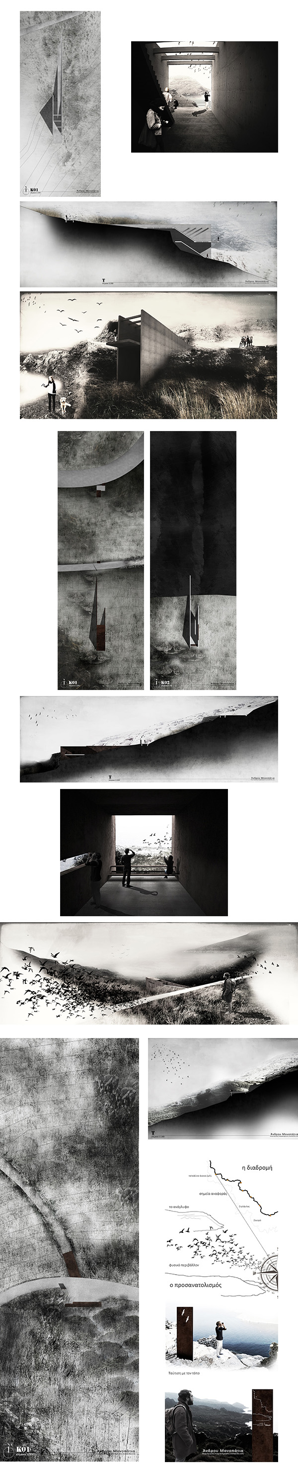
The main purpose of our thesis is to develop the west side of Andros Island, where the first signs of human inhabitation were found. We established a walking network taking as reference points some ancient settlements where the traveller familiarises with the place through the continuity and discontinuity of the site view. This intervention is found in a place where the degradation of the physical environment coexists with cultural heritage. The protection and conservation of the ecosystem, the information, the education and, finally, the management of the boundaries of the view were the main factors evaluated during the architectural process.
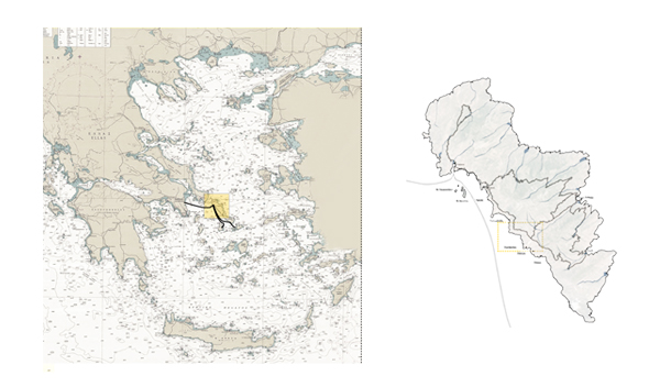
The Island
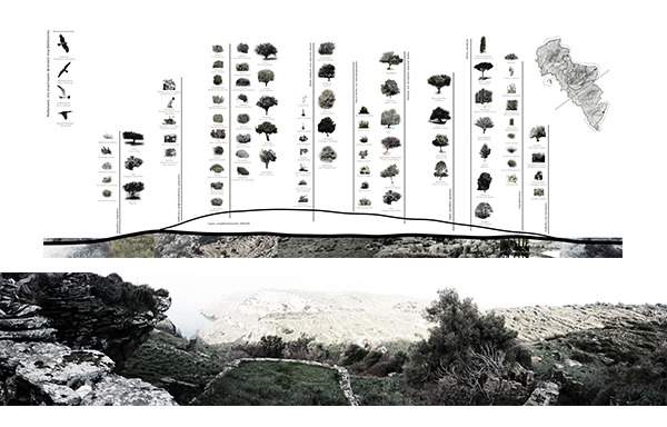
Andros Island is the northernmost island of Cyclades. Its great history, its traditional architecture, its climate, its vegetation, its abundance of water and its geographical location are clear evidence of the unique nature of this island. Many archaeological sites, such as Stofilas, Plaka, Hypsile, Zagora and Paleopoli are landmarks spread all over the island that reveal its strong cultural heritage. Four successive mountains with direction East-West, carve the relief of the soil and shape the geomorphological image of the island. Andros coast is made up of sheltered rocky coves, while between the mountains are formed deep canyons, narrow streams and extensive valleys. Moreover, estuaries of streams in the sea form coastal rich ecosystems. The avifauna of Andros has more than 200 species of birds and rocky beaches are the refuge for a variety of rare species.
The Dry-Stone Wall
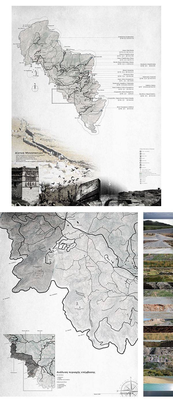
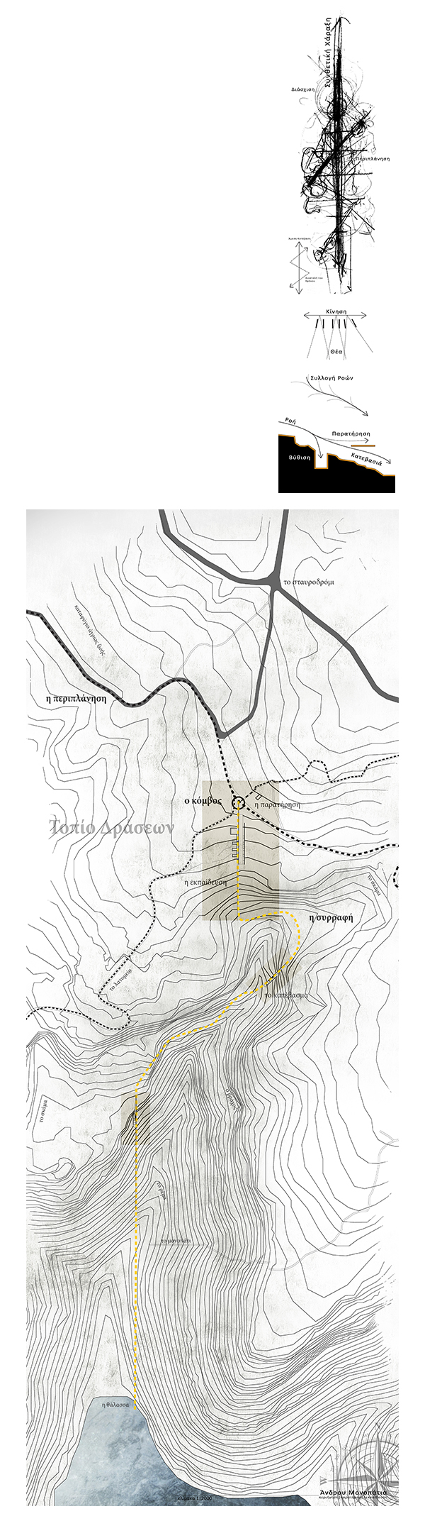
The physical structures of Andros are more accurate due to the dense network of dry-stone walls. This network stabilizes the soil and, simultaneously, reinforces the sense of microscale. The motion of the walker is defined by two perpendicular dry stone walls that make the landscape an object of continuously alternate viewings. Today, the network of hiking routes is calculated to be longer than 300km and hiking can contribute to the development of touring-tourism of the island.
The Area
An inactive quarry, a former dump, a sanctuary of the wildlife and three archaeological sites (Strofylas, Zagora, Stavropeda) form the identity of the intervention area. We identified the boundaries of the site which can be segregated into natural and anthropogenic ones.
The sea, the hills and the space between them are the visible physical boundaries of the area, while the settlements, the roads, the dry-stone walls, the quarry and the dump are the anthropogenic ones. A boundary, visible from most parts of the study area, is the sea, which also provides a system of orientation, while the wildlife refuge is a specified, but not visible, area.
Two residential complexes, Palaiopolis, in the North and Zaganiari, in the South, are two nodes developing a contributory relation between natural and human landscape. Thus, creating a contributory relation between Object - Area and Subject - Visitor could lead the visitor to gradually identify the site.
The Intervention
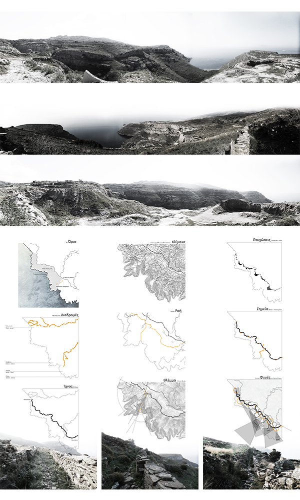
A linear path follows the traces of an existing dry-stone path and connects two mapped hiking routes, having two settlements, Palaiopolh and Zaganiari as its ends. This path is located above the road, follows the terrain's elevations and produce different perceptions and views of the site. Secondary routes start from the main path and reinforce the connection with the boundaries of the site. These routes allow the walker to wander through the place expanding time.
After passing the main path, the traveler crosses a natural environment and enters to a corroded landscape. Two excavations of the quarry and a landfill have caused a crack. We discovered that the direction of the flowing water matches with the one of the dry-stone walls through parametrical design.
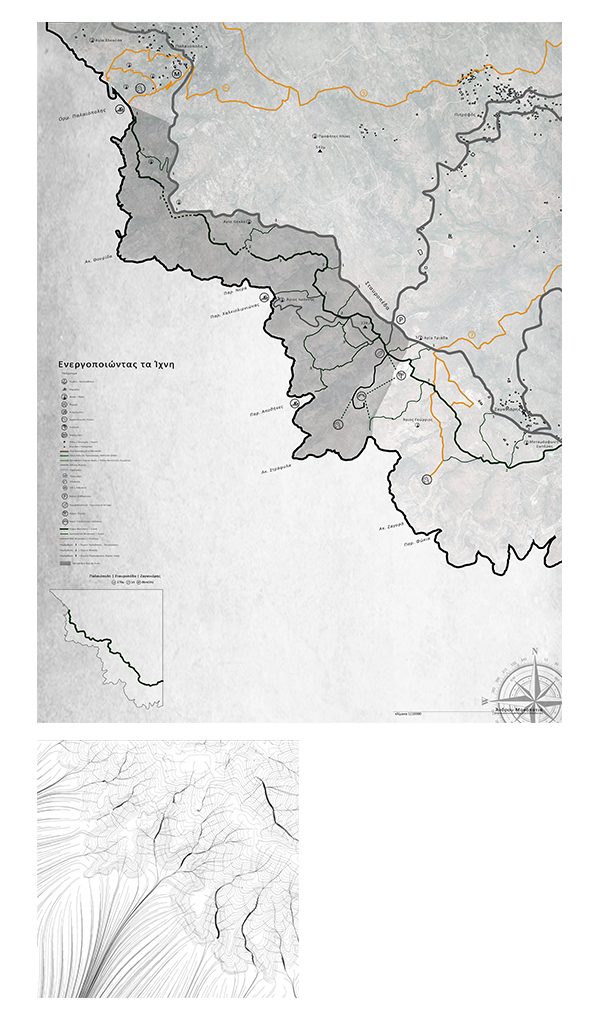
In Conclusion, through a wider landscape reformation our main goal is to stapple two hills, similarly to the flowing water and lead, thus, walkers to the beach. Two walls define the movement and the view; the intervention establishes three downshifts which lead to the beach. The downshifts emulate the design of the paths that follow the perpendicular direction to the height and engrave the relief soil.
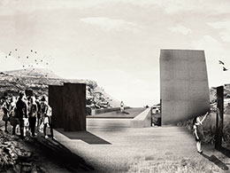
The establishment of an environmental center in the broken landscape is crucial and leads to the rehabilitation of the site. At the beginning of the route, visitors outline all the parts of the site. While crossing the first downshift through the building, towards the excavation, visitor faces the enormous crack; the visitor stands towards the rock, conceptually and visually. Subsequently, he is being led in the core of the excavation where, being surrounded by rock, he realizes the large - scale deterioration of the natural terrain. The path continues through the second downshift to the stream, where a second smaller excavation site creates inner feelings with direction to the former. Outdoor cultural activities could take place in the excavations of the quarry. Finally, the path ends with the third downshift which leads to the sea.
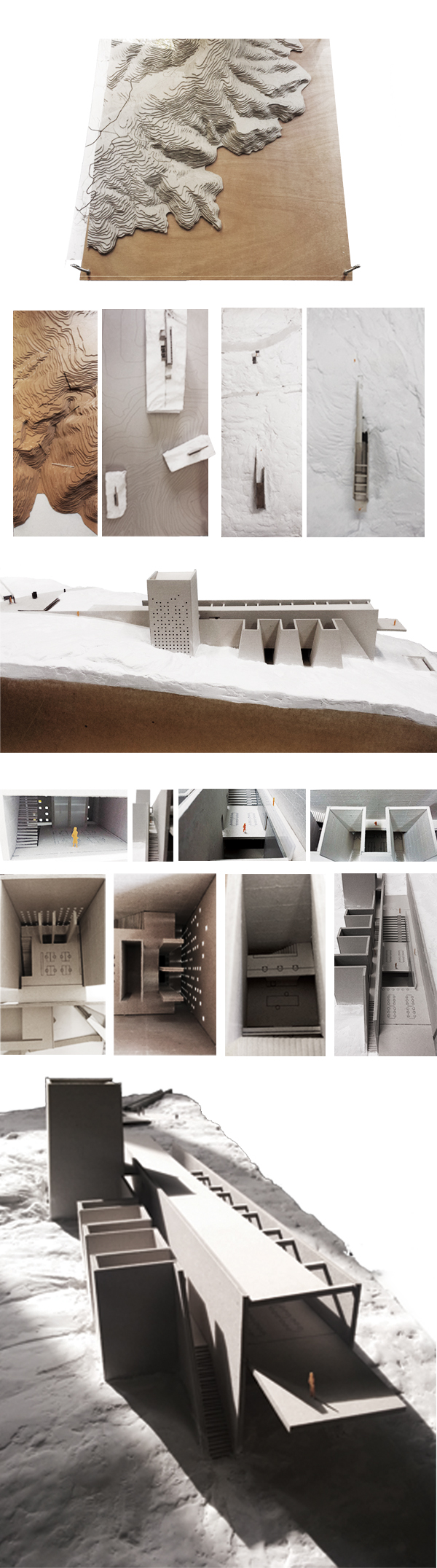
The key synthetic idea was the outdoor vertical crossing of the building. The point and the line represent the stance and the direction of movement respectively. The axis of movement separates the education part from the research and the information ones. All movements inside and outside of the building are defined by light and direct the view to the landscape. Visitors inside the building move through a progressive gradient of light and view.
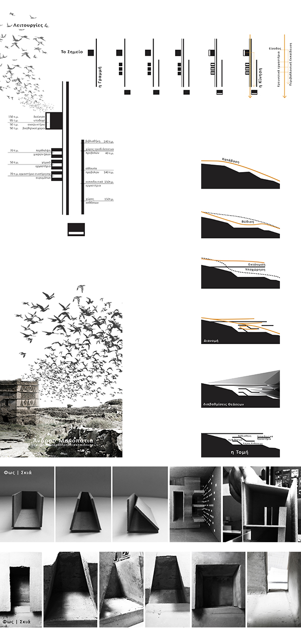
Entrance and vertical communication marked with reference to the tower dovecote. At the sector of education there is an open space available for various functions which have not been specified. The research part, which constitutes of three repetitive elements, is separated from the main building through the outdoor movement.
There is diversity in the ways that the light enters the building. Daylight enters through small openings in the tower. In contrast, at the research area, the light enters from above creating, thus, mysterious atmosphere. At the main part of the building and along the axis of movement there is a longitudinal slot in the ceiling, which allows the light to enter. Two solid walls, made of concrete, increase the visual leap into the view, while the gap between them becomes the main source of light to the space.
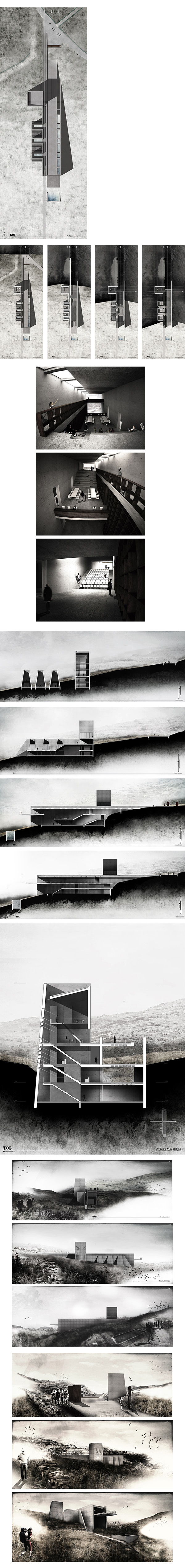
The main goal of our proposal is the smooth movement following the natural relief of the quarry. Thus, we establish a building which is "born" from the ground. Two walls that produce the movement articulate the Observatory Tower. Along the main path, there are bird-watching areas and light structures placed on the ground, made of corten for better landscape intergration. Observation points along the main path, where the visitor can obtain information for the site, are likewise light structures made of corten,