STUDENTS PROJECTS
PROJECTS2012
06 May, 2013
Network of point interventions at Larnaca salt lakes (Cyprus)
Three seasonal routes.
Student: Michalis Piroccas
Tutor: Panos Dragonas
University of Patras, School of Architecture
Date: June 2012
The proposal is a combination of 3 seasonal routes which take into account the characteristics of each period and lead the visitor to important points for each season. The proposal, by maintaining the characteristics of the 3 periods and through 3 seasonal routes, aims to make people compatible with the habitat.
Larnaca salt lakes are located in the southwest of the city of Larnaca. It is the second largest of the four coastal halophytic wetland systems in Cyprus. The uniqueness of the area is enhanced by the fact that it contains the only super-salty lake in Cyprus, Aliki. The ecosystem is part of the "Natura 2000" network, while the Great Lake has also been included, since 2001, in the list of Wetlands of International Importance under the provisions of the Ramsar Treaty.
The Salt Lake was a major source of salt for Cyprus until 1980 when salt production stopped, due to the contamination of the habitat from the adjacent urban infrastructures. Because the Great Lake is not a colony of migratory birds, but just a stop, time is divided into 3 periods. The first period runs from December to March, the second from April to May and from October to November. The third from June to September. A common feature of all three periods is the fact that people seem to be undesirable as there is no proper access to the habitat. The proposal, by maintaining the characteristics of the 3 periods and through 3 seasonal routes, aims to make people compatible with the habitat.
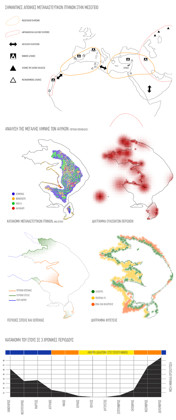
The 1st route, which is the longest route, is active between December and March, while one part of the route is active during the summer. This period is characterized by a great concentration of birds, so the route is focused on birdwatching. The 2nd seasonal route is active during October, November, April and May and can be done by water since the absence of birds allows the entry of man into the water. The 3rd seasonal route is revealed due to the evaporation of water. It is active from June until September and is an extension of the 1st route. The path is formed within the water basin by placing stones and is revealed during the summer season, the season of salt harvesting. This is the route that leads to the salt flats, where people can watch the revival of salt harvesting.
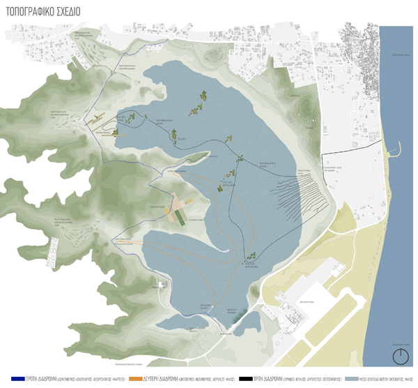
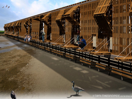
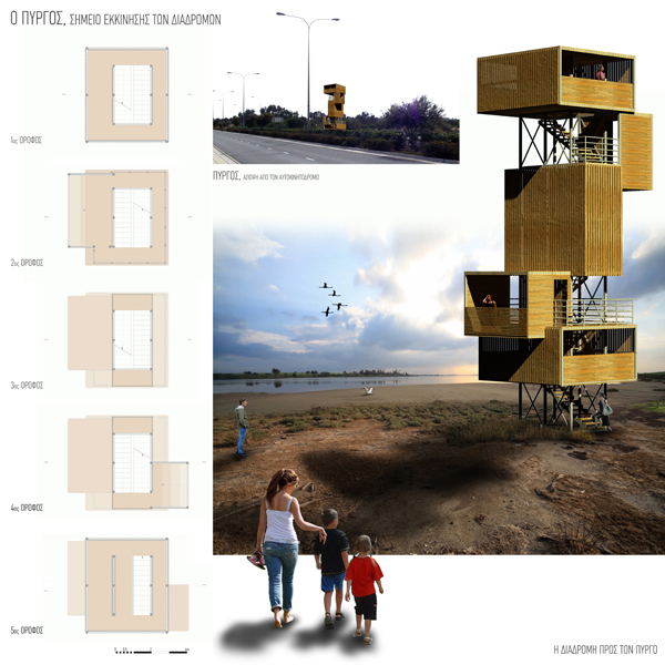
First point of intervention is the tower, placed at the beginning of the path. Due to its size and position, the tower acts as a "decoy" and invites the visitor to the habitat. Its role in the operation of the route is quite significant as it marks the starting point, invites the visitor and offers views on important points of the area. Through these views, the visitor can understand the importance of the proposal and the importance of the wetlands for the city of Larnaca.
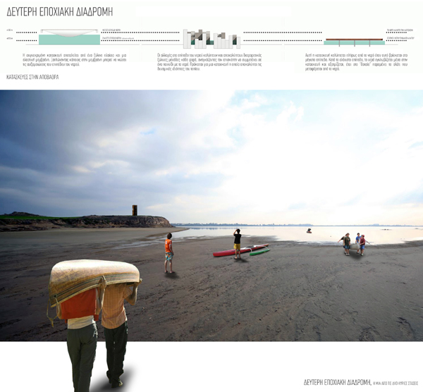
After the tower and along the proposed route we find the wooden pier. The Pier is the starting point of the second seasonal route and during October, November, April or May, visitors can take a canoe. This route can be done by water since the absence of migratory birds during these months allows the entry of man into the water. The two main stops of this route, are placed in the areas where the topography and the water are forming a kind of beach, which allows an easy entry and exit of the canoe to the water. Part of the second seasonal route are several floating stops, which are placed inside the salt lake. These stops set the path to be followed by the canoe without disturbing the birds and destroying the halophytes. If we are not in the months that activate the floating path we continue to the first seasonal route. Along the way we see the Hala Sultan Mosque where the path gives us the option to visit it.
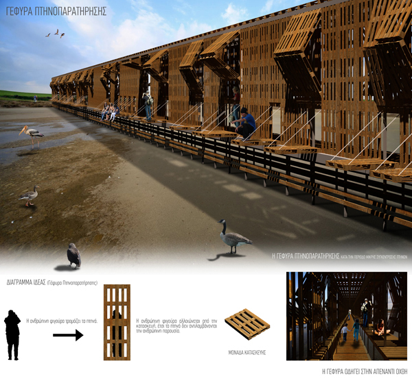
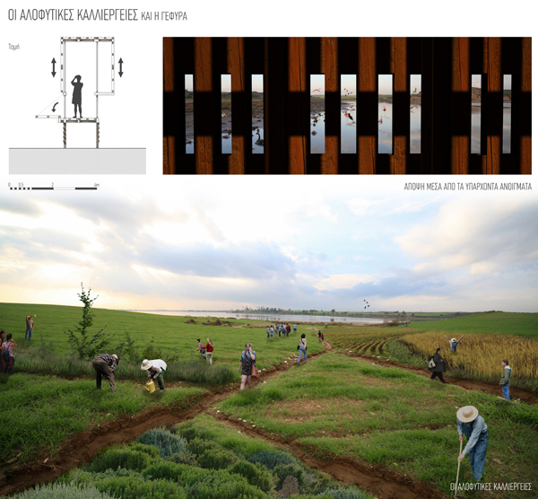
After the Mosque we find the birdwatch bridge. It is placed on the first seasonal route and in an area where the artificial islands enhance the habitat and increase the population of birds in that region. The bridge is made of the specific wooden panels because the human figure scares the birds. These units mar the human figure and so the birds do not perceive the human presence. The units that are placed at the top can be dragged upwards, while the third part that is located at the bottom can be rotated and create an outer seat. If the conditions permit it (very low concentration of birds), the visitor can sit outside and enjoy the view of the artificial islands and the birds. If the concentration of birds is increased, the panels remain in their "original" vertical position and the visitor can look through the existing openings in the wooden units.
The bridge leads the visitor to the opposite shore of the salt lake. This prevents the pedestrians from entering into the salt lake. Thus we avoid the destruction of halophytes and the disturbance of the animal community. On the opposite shore we find the halophytic crops that are placed in the area where today, farmers cultivate cereal using heavy machinery, which is detrimental to the wetland. The proposed halophytic crops are placed away from the coastline and therefore away from the areas where the birds nest, while the cultivation is done without the use of machinery and with the participation of volunteers and visitors. The volunteers and the visitors can cultivate the halophytes that are going to be used to restore the habitat, while at the same time the visitors get educated about the halophytes and their characteristics (resistance to salt and water).
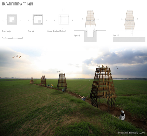
Close to the crops, in the area known as the "TONGUE", are placed bird observatories. This region was selected because is the region with the most nests. The central region as the most important point is formed as a place for observation and education. This region is used to date as a farmland. The activity is incompatible with the landscape and it is proposed to cease. Due to the high concentration of nests in the area, the path that leads to the observatories is dug so that the visitor will not be perceived by the birds. The visitor enters into the observatory from the bottom, using the ladder inside the trench, while the shades alter the shape of the human body so that the human figure cannot be understood even when people are located within the observatory. The proposed observatories are located approximately 20 meters from each other to avoid large concentration of people and to reduce noise in a sensitive area such as this.
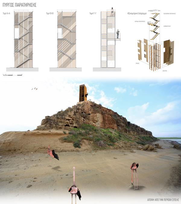
Next intervention in the region is the Observation Tower that is mounted on the peninsula of the salt lake. The tower consists of two parallel cores. The first core has a stairway and is enclosed by blinds, while the second one is the continuation of the staircase and allows certain views at certain points (through the absence of the shades). The tower is placed on the highest point of the region and acts as an observatory for the region and the city.
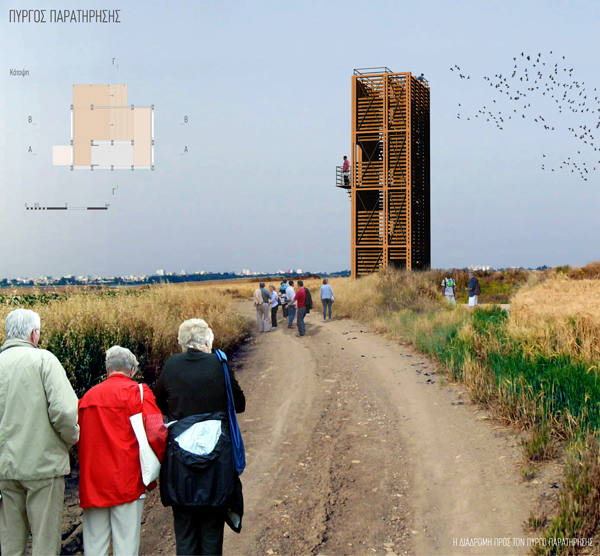
The tier on the exterior of the tower faces the area where the birds are fed, while the last level provides oversight of the whole region. The location and height of the tower make this building as a sign of navigation in the wetland and is visible from every point of the proposal.
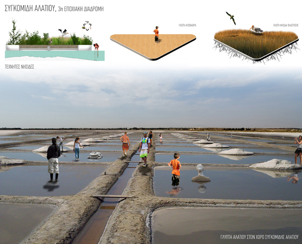
The last stop of the first route are the sloping surfaces. The sloping surfaces are placed in front of the second stream that enters the wetland. This creates a game between the visitor and the water, the water level determines which surface is accessible and which not. From this point, visitors can follow the trail that leads them to the exit. However, if the visitor is here in June, July, August or September due to the evaporation of water the path of salt (3rd seasonal route) is revealed in front of him. The path is formed within the water basin by placing stones and is delimited by placing floating islands.
The floating islands are placed inside the wetland, near the areas where urban development destroyed the vegetation. In this way we manage to restore the vegetation and the birds find a place to nest. The base of the islands is made of grid and allows water to enter for plant growth. Plant residues enter into the water offering food for the water species that are the main food of migratory birds. In this way we create a kind of chain between the birds, the halophytes and the fauna. When the water evaporates the islands "sit" on the ground without crashing the fauna that lives into the soil as the bottom of the islands keeps a distance from the ground.
Part of the proposal is the revival of salt harvesting. The process begins with the celebration of a festival that takes place on the last week of July, when the route is revealed and the water has evaporated. During the ceremony, people form the "salt flats" and the salt harvesting starts. The ceremony signifies the end of the previous annual cycle of the wetland and the beginning of the next. At the same time a contest will be conducted, where visitors will compete for the best salt sculpture. By the end of the 5th week (duration of salt harvesting in the past) the salt is removed from the wetland and destroyed as is unfit for consumption.
The process of harvesting and the removal of salt contributes to the gradual restoration of the wetland as a large volume of contaminated material is removed from the site. Over the years this process can lead to positive results and the salt can become suitable for consumption.