STUDENTS PROJECTS
PROJECTS2013
Students: Ioanna Koulouri, Nikos Spyrou
Tutor: Yannis Aesopos, Associate Professor
University of Patras, School of Architecture
Date: October 2013
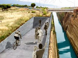
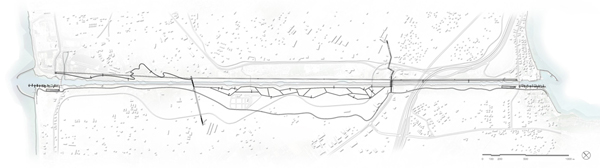
References to the Corinth Canal are usually associated with the section where the National Road is passing through, as it is the only active part of the area while the rest remains almost inactive. The few activities that take place seem to ignore their direct relationship to the Canal.
But following the Canal from West to East, one will be able to recognize the Isthmus history from antiquity until today through the traces of history. By locating these traces on the map, a spatial continuity is noted leading to the following time categorization: antiquity - opening of the Canal - 2nd World War - construction of the National Road - current situation.
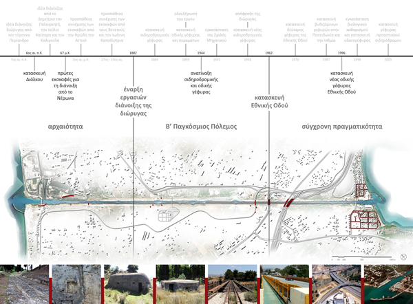
Following this approach a route can be planned along the Canal, which passes through all the above mentioned historical phases and illustrates the history of the area.
The first part of this route is the antiquity part, which follows the existing traces of the ancient Diolkos with respect to the ground formation in order to keep gentle inclines, referring to the way the ancient Diolkos was constructed.
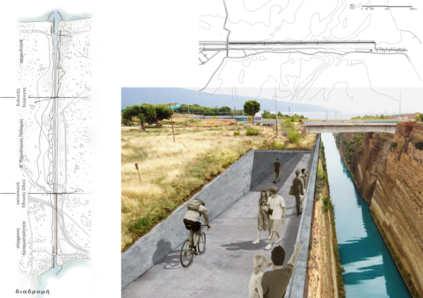
Τhe second part refers to the opening of the Canal. The route reaches the point up to which the Roman emperor Nero stopped the excavation, goes across the Canal and offers a more direct view of it.
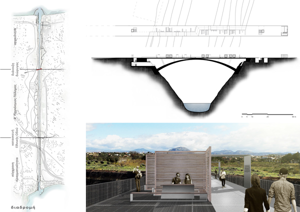
Since the construction method of all the bridges across the Canal indicates the period of their building, modern technology is used for the construction of this bridge in order to continue this codification.
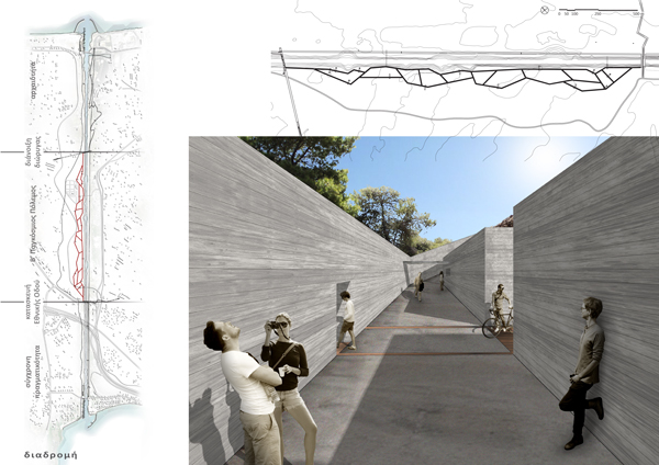
At the 2nd World War part, the course immerses into the ground and becomes mazy, referring to trenches. The level of this immersion depends on both the constantly changing terrain and the ramps.
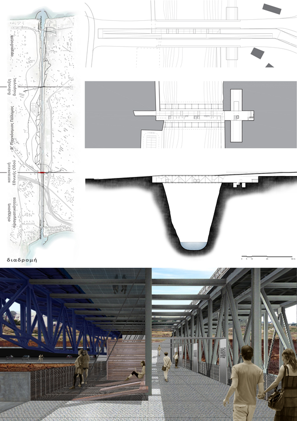
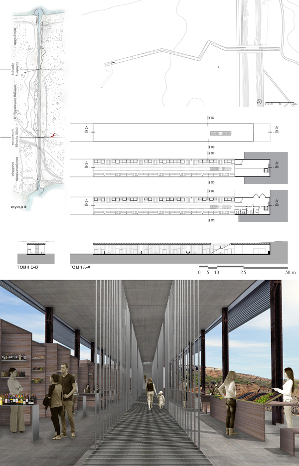
The part referring to the construction of the National Road passes between the two bridges on two levels; one at the level of the Highway and the other on a lower one.
The construction method of this bridge is similar to the one used for the National Road, since it is an extension of the existing bridges rather than a new construction.
The last part (the present reality) refers to the ideas of "passing by" and "high speed" and therefore it consists of a united straight line with gentle inclines all along.
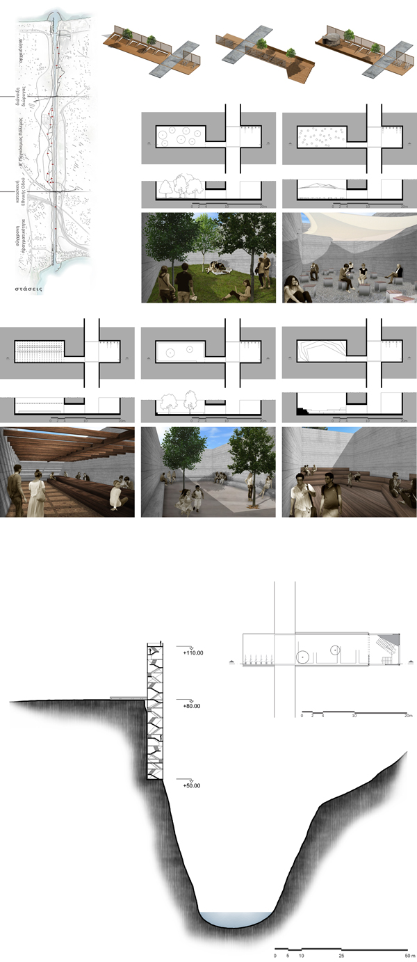
Two kinds of stopovers are formed along the course; the simple and the informative ones.
The simple stopovers are located vertically to the course including the existing flora. At the 2nd World War Part, as the stopovers are immersed and isolated from the environment, they require special spatial quality. For that reason there are five different qualities based on different ways of rest.
The informative stopovers are located on spots along the course, which are of significant interest and their formation remains the same as the one of the simple stopovers. The only difference is their ending, which is determined by each spot and it could be an amphitheater, a bunker left from the 2nd World War operating as a projection room, or an observatory at the highest point of the Canal. The latter is developed both upwards and downwards, while its staircase is formed in such a way to offer various views of the Canal and the surrounding area.
The two bridges of the course are extended toward the inland, so they operate as anchor points for the proposal giving the visitor the opportunity to realize the current situation of the surrounding area.
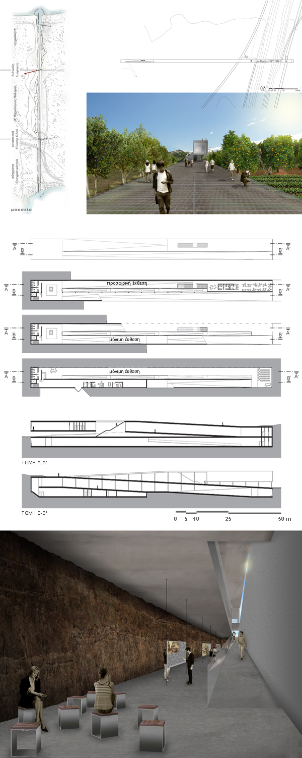
The anchor point relating to the opening of the Canal crosses the farms and leads to a museum where the opening works are presented in depth.
The museum's roof is accessible and its volume is bisected by a public route connecting the anchor point - and so the proposal - to the surrounding area. The access to the museum is obtained through a ramp which takes the visitor underground, as it refers to the first procedures that took place during the opening, such as the excavation. For the same reason, the ground of the area forms the walls of the lobby and the first part of the exhibition. The exit from the museum is obtained by the public route.
At the anchor point referring to the construction of the National Road, the visitor can ascend from the course level to the highway one and move between the two bridges for a while. Afterwards, the visitor comes, through a ramp system, to a market which refers to the top of commercial and tourist activities developed as a result of the National Road construction.
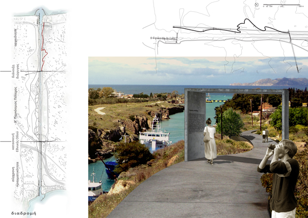
The system ending points constitute the Canal entrance and exit, as well as the "meeting point" of land and sea. In order to emphasize that border, a different approach for each ending is chosen.
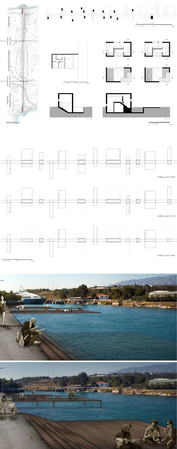
On the side of Poseidonia, the border between land and sea remains clear, strict and unchangeable. The fact that Poseidonia is a relaxing place with low traffic makes the area proper for guest rooms.
At the end of Isthmia, the border between land and sea is dynamic and changeable. The surfaces vary toward the altitude and the landscape constantly changes because of the tide. Also, the settlement demands an organized public space, so some of these surfaces remain free while other are equipped with seats.
Access to the intervention is obtained at the points where the two anchor points and the two immersing bridges are located, turning them into reference points of the proposal. The access points are also approached by a cable vehicle north of the Canal and by a motorway south of it, which leads to parking areas.
The cable vehicle actually constitutes another layer, which allows observation of the route from high up, offering a completely different experience than walking. However, this aerial course is not essential, as the whole proposal can function with or without it.
In order to avoid affecting the horizon, the parking areas close to the immersing bridges are located 1.5 m lower than the ground surface and those close to the anchor points are located underground. The presence of the latter is indicated by a longitudinal opening on the slope.
The proposal as a whole can serve a variety of scenarios of sojourn.
Scenario 1: The course can be characterized as an open-air museum, which gives the visitor the ability to stop for few hours and continue their way afterwards. At the same time, there is also the option of partially visiting the intervention, as the access points allow each part of the course to function independently.
Scenario 2: By examine a secondary scenario for longer sojourn, the visitor can deviate off course at the bridge points, following their extension into the inland, where they have the opportunity to study the area on a second level and to get to know it deeper.
Scenario 3: The guest rooms give the option of staying at the area and the visitor can pass to a third level of study, observing the progression of the activities that take place during the whole day or even the week, the month, the year.
It is a proposal which, following the traces of the history of Isthmus, aims to activate the Canal axis, in order not to constitute a few minute stop of travelers but to become their destination.