STUDENTS PROJECTS
PROJECTS2013
24 May, 2015
Formulation of movement and observation at the salt lake of Larnaca
The objective of this diploma thesis is the introduction of several interesting activities in the Salt Lake area which will eventually turn the location into an attraction for visitors.
Student : Vasia Konnari
Supervisor professor: Kostas Manolidis
University of Thessaly - Department of Architecture Engineering
Date of presentation: 3 July 2014
All of the following projects proposed, aim to preserve the biodiversity as well as enhance the relationship between man and nature.
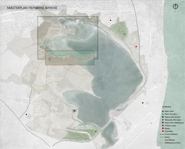
The Location
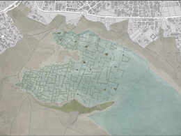
The study area of this project is the Salt Lake, situated in the south of the city of Larnaca. The lake is one of the most distinctive landmarks and a natural reserve of great importance for the city.
It is a complex network of four Salt lakes, of different sizes. The largest lake, Aliki, covers an area of 449 acres and a perimeter of 11.5 KMs. On the west bank, lies the Hala Sultan Tekke and the old aqueduct, which dates back to the 18th century.
History
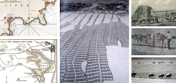
The history of this great landmark begins in prehistoric times. During that period, the lake was larger and connected to the sea. During the winter months, the lake fills with water whilst in the summer the water evaporates, leaving a crust of salt and a haze of grey dust. The salt is what makes this lake so famous, as it used to be one of the islands major exports. Salt harvesting stopped in 1987.
Flora and Fauna
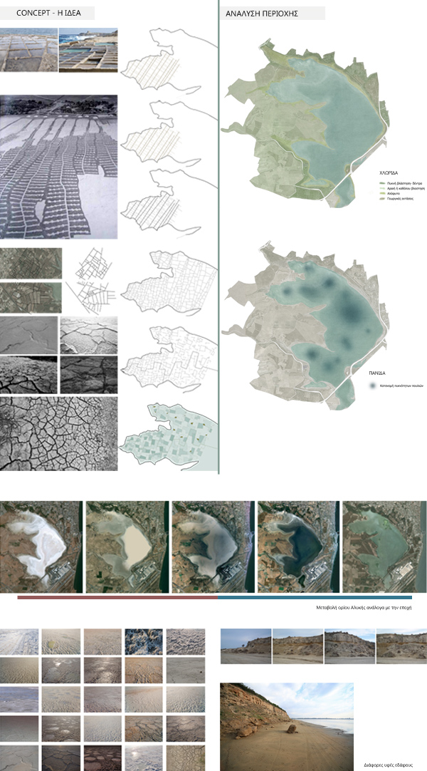
The flora of the Salt Lake area consists of many plant species and halophytic plantation. In addition, the wetland accommodates vast numbers of waders and marine birds. Many of them stay over winter (flamingos, wild ducks and seagulls), some stop by during their spring migration, while others repopulate at the area.
Climate - Water inflow
The main source of water of the Salt Lake is precipitation (rainfall) and the water can be as deep as 2 meters, although the majority of the area does not exceed 0.3 meters. During summer, due to high temperatures and winds, the lakes dry out.
Topography of the area
In the North-West of the salt lakes we can see interesting topographic formations, short hills with smooth gradients and shallow valleys, creating spaces and views with interesting aesthetics.
Concept
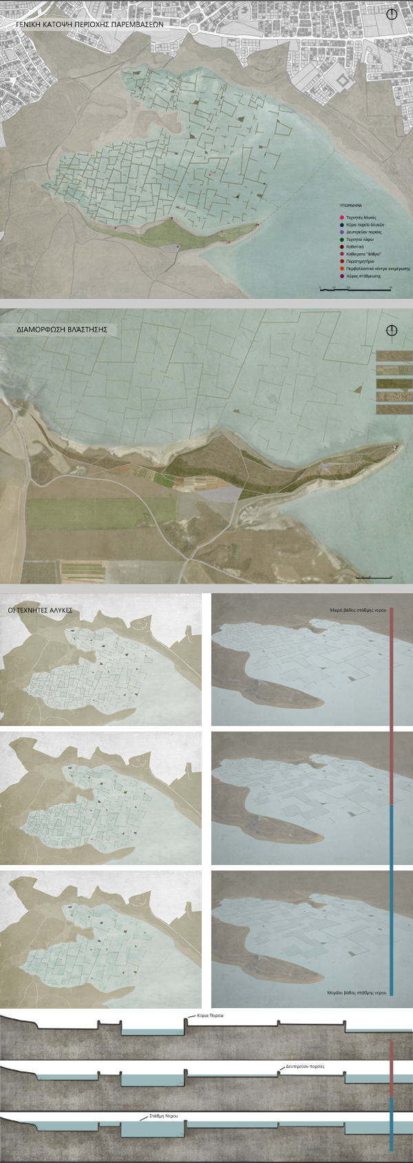
The initial design idea was the unification of the two existing paths, creating one perimetric route and some point interventions.
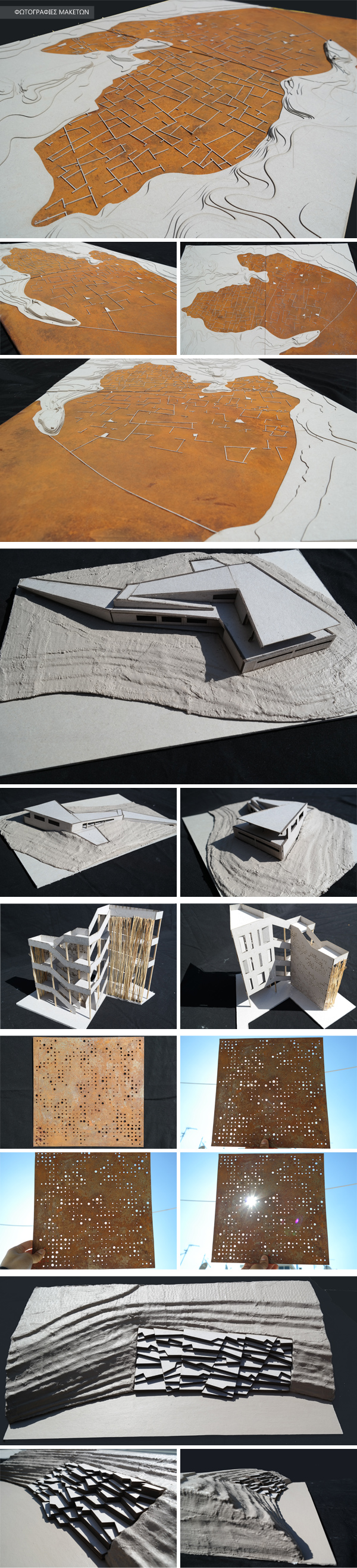
Another idea was the revival of salt harvesting, bringing man and nature closer/together as well as the simultaneous conservation of the character and the natural wealth of the area. This was achieved with the creation of artificial salt lakes, while man-made hills inside the lakes, can help the plantation grow and give extra space for the birds to nest. The grid design of the salt lakes was based on the formations of the lake during the period salt harvesting was still active, the adjustments of the area's land plots, the different textures of the ground and other salt lakes.
Area of Interference
After various designs and site studies, the area of interference was limited to the north-west part of the lake due to important view points and the morphology of the ground. This could help all the proposals.
Vegetation
Part of the proposal is the design of the area's vegetation which includes two crops; one, in front of the Information Centre, where mainly aromatic and other undergrowth vegetation will be cultivated. In the second one, the vegetation cultivated will be tall. Also, reeds and halophytes will be planted close to the lake. All of the proposed plants already exist in the area.
The artificial Lakes and the "Islands"
The Salt lakes consist of path ways 1.20 or 0.70 meters in width. These ridges and "islands" are made of natural materials (mud, soil and stones). As the grid moves further away from the banks, it follows a fragmented order. At some points, there will be height differences far into the lake.
These lakes, besides reviving salt harvesting, aim to create new routes inside the lake, giving the visitor the opportunity of exploring the environment. The routes are adjusted according to the season and the level of water due to the different heights of the ridges.
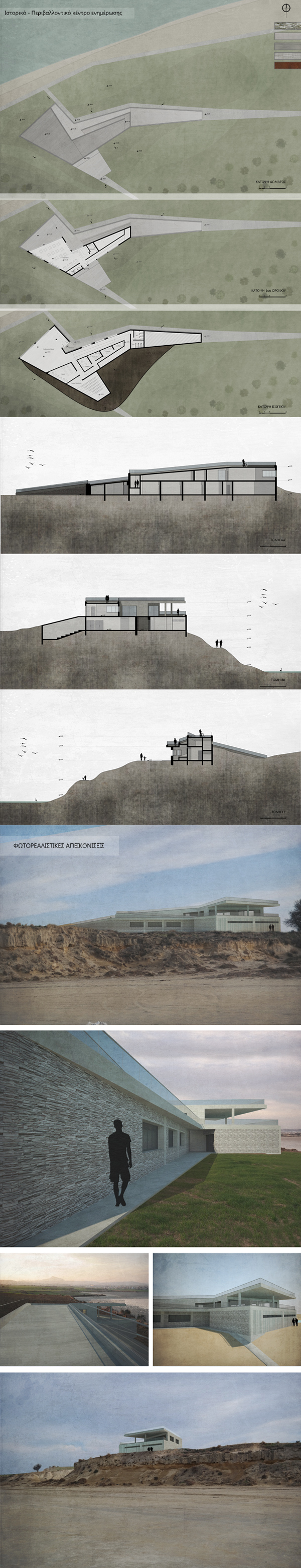
Historical - Environmental Information Center
The design concept of the Centre was to be a continuation of the proposed routes. In this way, the building has a passable roof while its back elevation is submerged in the ground. In this way, the natural scenery will remain visibly unaffected by the interference. The building mainly consists of exposed concrete, while in some places, stone is placed. Movement between the different levels is achieved using a perimetric ramp following the concept of the passable roof.
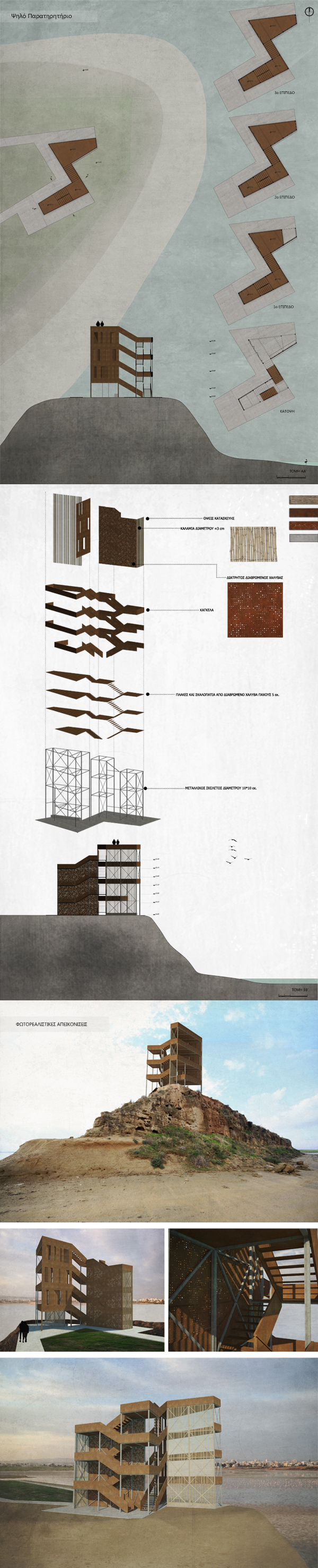
High Observatory
The observatory is placed at the highest point of the Salt Lake's perimeter, allowing the visitor to enjoy a panoramic view. The observatory will be a light and temporary construction in order to maintain the natural habitat. The materials chosen are: eroded steel, metal supporting elements and reeds. On one side of the construction, translucent surfaces are used, while on another one small openings (small windows) were created. On the two remaining sides we used reeds. These elements helped create an interesting play between lights and shadows.
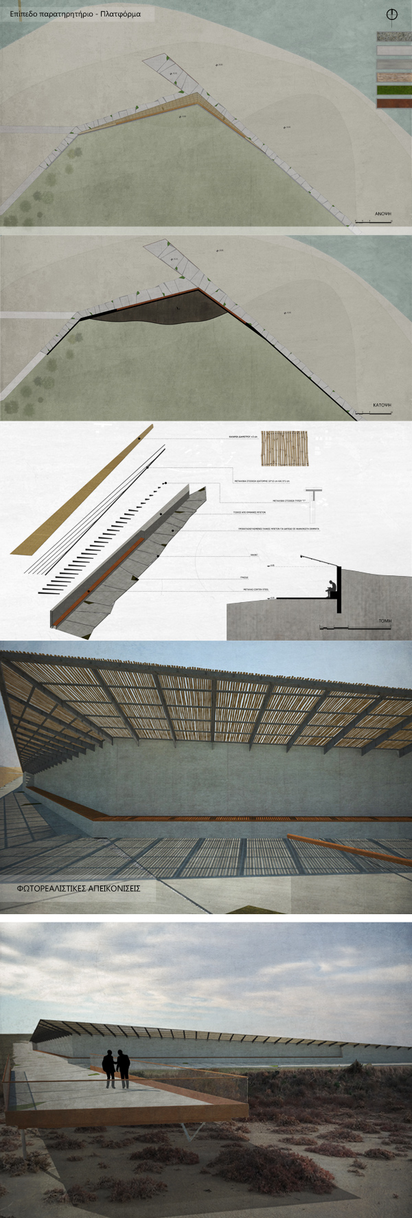
Flat Observatory- Platform
This observatory, like the Environmental Information Center, functions as a continuation of the proposed routes. In this way, the visitor is led at a place where he can watch the birds, the artificial lakes and the different shapes that were created. It consists of a concrete wall, metal supporting elements and reeds while the floor is made of irregular concrete pieces, weeds and gravel.
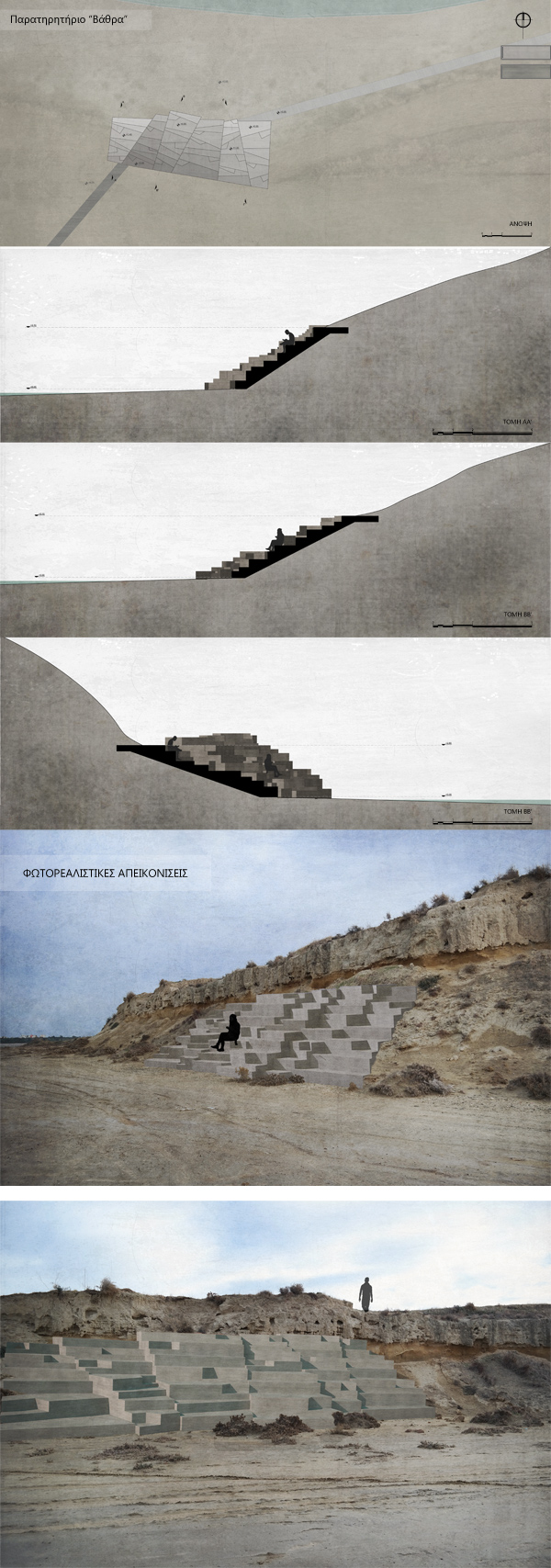
Observatory - Pedestals
This structure is divided in two parts and placed at two points of the Salt lake; the banks of the hills. The height of their steps is uneven. The asymmetry of the structure and the roughness of the surface aim to resemble the rough and the relief patterned ground.