STUDENTS PROJECTS
PROJECTS 2011
11 May, 2012
Reforming the landscap l Tourkovounia
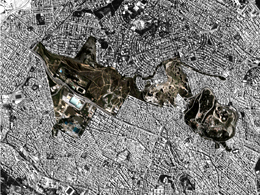
The subject of the diploma project is Tourkovounia, three hills centrally located in the basin of Athens.
Student: Potiriadi Ioanna
Supervisors: Mp. Mpampalou, I. Micha
School of Architecture, National Technical University of Athens
Date of presentation: 05/12/2011
The subject of the diploma project is Tourkovounia, three hills centrally located in the basin of Athens and more specifically the free, unstructured space that has remained as the negative shape of the expansion and densification of the urban fabric.
Through the understanding of the site as goal emerged, the exploration of a different approach of the remaining 'natural' space, the recovery of its identity by reading its formation through history and the successive changes it has undergone and finally the renegotiation of its boundaries with the surrounding urban fabric, so that it transforms into an organic part of the city.
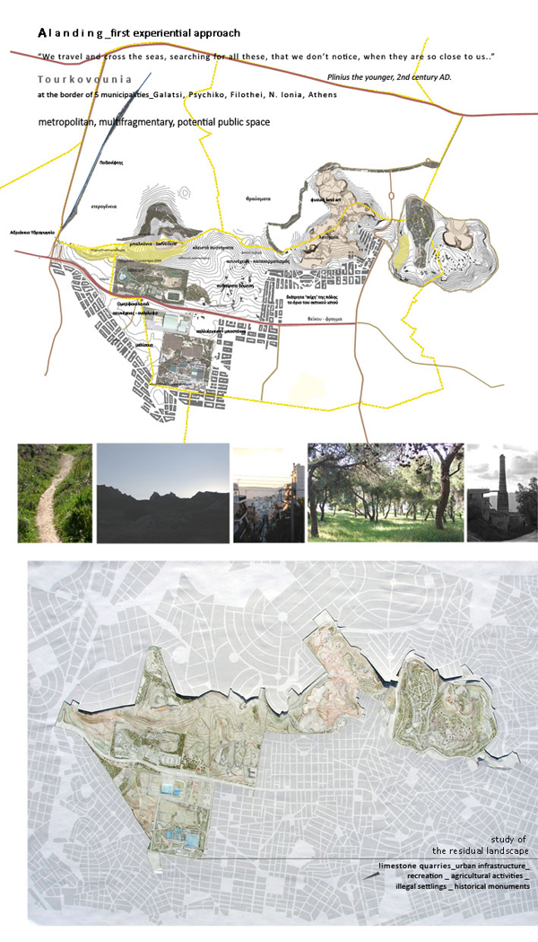
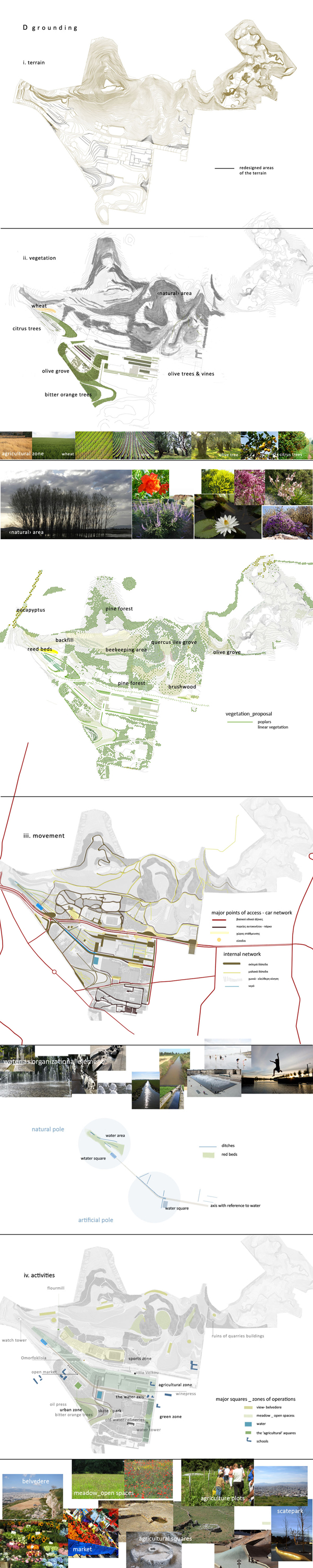
The first experiential documenting of the characteristics of the site is followed by the examination of its evolution through time and by the analysis of the existing situation into the different layers that compose it: the physical parameters (terrain, geology-water, flora), the limestone quarries, the urban parameters (road network, buildings, closed systems, fragmentation of the negative shape, the typology of the boundaries). Through this examination the problematic situations and important elements that will guide the proposal emerge.
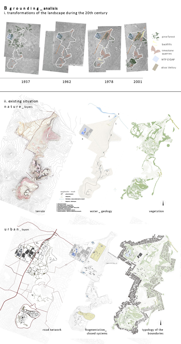
The fragmentation of the site by two avenues with heavy traffic (Omorfokklissias-Veikou & Anagenniseοs), the closed systems (the water treatment plant of EYDAP, the Olympic gym constructed in 2004 & the Veikou park) and the illegal settlements, in conjunction with the morphology of the terrain at places and the inactive quarries 'injure' and render inaccessible a metropolitan and otherwise engaging area.
The addition of an extra layer of intervention is proposed, that based on the reading of the existing terrain, the physical factors, the mayor flows of movement from and to the city and the existing infrastructure will
-reform internally the negative shape and rejuvenate the natural elements
-renegotiate its boundaries with the urban fabric &
-suggest a program of operations that will enhance the identity to the site.
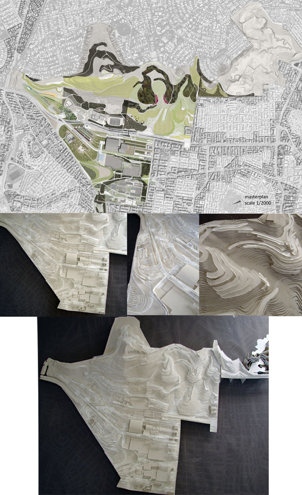
The proposal is organized into two parts: at a strategy level it studies the gradual recovery of the two northernmost hills (total area: 2500 acres) , while at a design level it focuses on the site east of the Veikou-Omorfokklisia avenue, adjacent to the boundary of Nea Ionia (700 acres).
Basic principles of the proposal is first the holistic study and management of the remaining 'natural' space -that till now does not characterize the treatment of the site- and second the gradation of the intensity of the treatment and the organization of the program of operations into zones according to the character of the existing situation, the accessibility and the terrain.
More specifically, the part east of Omorfokklisia avenue because of the gentle slopes of the terrain has been conquered by urban infrastructure, is to great extent man-made and thus requires -and allows- the most 'aggressive' treatment both spatially and as far as the proposed activities are concerned.
It is followed by the agricultural zone -the geometricized and tamed for the human needs nature- the middle ground between the urbanized and the 'natural'. The linear treatment of space organizes the movements between the urban fabric and the residual 'natural' area. At the same time the agricultural plots introduce a productive and educational activity that rejuvenates the everyday life of the area.
At the slopes of the hill where the human intervention (grazing, timber-felling, reforestation, quarrying and backfills, temporary and illegal building) has shaped the land, the proposal is centered around the reinforcement of the natural elements.
And finally the quarried hill is viewed as the area that requires the least intervention and is treated as place of memory and observation of geological processes.
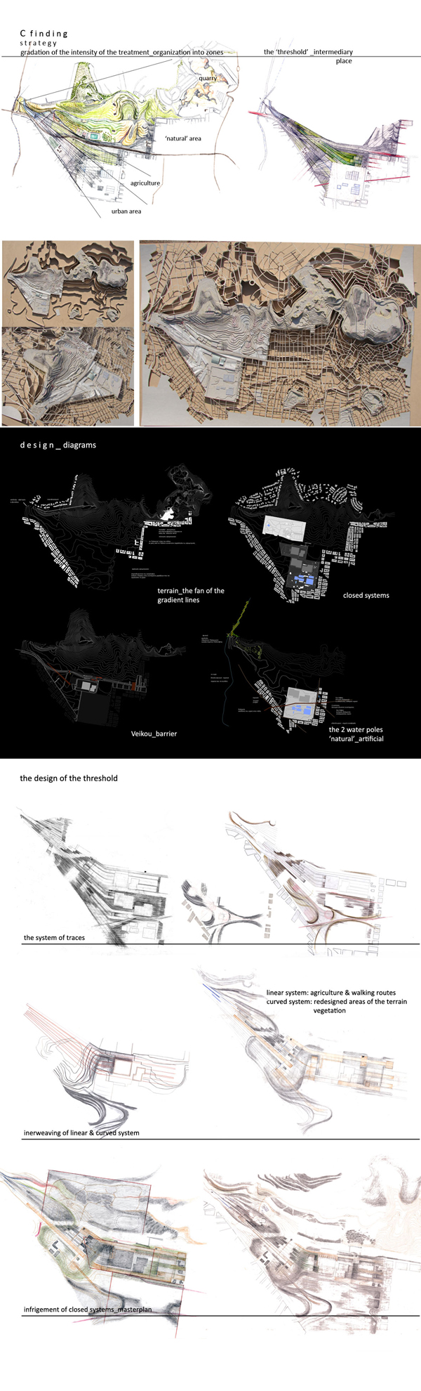
Architecturally, I focus on the area east of Omorfokklisia avenue. Bordering to high density urban areas it may function as a 'threshold', an intermediary space between the 'city' and the 'natural' residual area.
The creation of a system of traces is proposed, which scanning the landscape, transforms parts of the terrain and creates a second reference system, on which the fragments of urban infrastructure fit, infringes the closed systems and embraces the hill receiving and filtering the movements from the city.
The element that organizes symbolically and architecturally the space is the water. The system of the traces that scans the landscape connects an artificial and a natural pole with reference to the water: the water treatment plant to the south with the reed beds, the boxed stream of Podoniftis (they give evidence of an underground karst aquifer) & the Handrian Aquadect to the north. Architecturally the water is expressed with the ditches in the agricultural area, the water elements along the walking routes and the two 'water' squares.